The Russian Plain is one of the largest plains on the planet. It is located in the eastern part of Europe, which is why its second name is the East European Plain. Since most of it is located on the territory of the Russian Federation, it is also called the Russian Plain. Its length from north to south is more than 2.5 thousand kilometers.
Relief of the Russian Plain
This plain is dominated by gently sloping terrain. There are many natural resources of Russia here. Hilly areas on the Russian Plain arose as a result of faults. The height of some hills reaches 1000 meters.
The height of the Russian Plain is approximately 170 meters above sea level, but there are some areas that are 30 meters below sea level. As a result of the passage of the glacier, many lakes and valleys arose in this area, and some tectonic depressions expanded.
Rivers
The rivers flowing along the East European Plain belong to the basins of two oceans: the Arctic and the Atlantic, while others flow into the Caspian Sea and are not connected with the world ocean. The longest river, the Volga, flows through this plain.
Natural areas
On the Russian Plain there are all types of natural zones as in Russia. There are no earthquakes or volcanic eruptions in this area. Tremors are quite possible, but they do not cause harm.
The most dangerous natural phenomena on the East European Plain are tornadoes and floods. The main environmental problem is soil and atmosphere pollution due to industrial waste. There are many industrial enterprises in this area.
Flora and fauna of the Russian Plain
On the Russian Plain there are three main groups of animals: arctic, forest and steppe. Forest animals are more common. Eastern species - lemmings (tundra); chipmunk (taiga); marmots and gophers (steppes); saiga antelope (Caspian deserts and semi-deserts). Western species - pine marten, mink, forest cat, wild boar, garden dormouse, forest dormouse, hazel dormouse, black polecat (mixed and broad-leaved forests).
The fauna of the East European Plain is greater than that of any other part of Russia. Due to hunting and changes in the habitat of animals, many fur-bearing animals suffered for their valuable fur, and ungulates for their meat. River beaver and squirrel were trade items among the Eastern Slavs.
Almost until the 19th century, the wild forest horse, the tarpan, lived in mixed and deciduous forests. Bison are protected in the Belovezhskaya Pushcha Nature Reserve. Beavers have begun to be successfully bred in the Voronezh Nature Reserve. The Askania-Nova steppe reserve is home to a variety of animals from Africa, Asia and Australia.
In the Voronezh regions, an elk appeared and the previously exterminated wild boar was restored. The Astrakhan Nature Reserve was created in the Volga delta to protect waterfowl. Despite the negative influence of humans, the fauna of the Russian Plain is still great.
The following natural zones are clearly defined on the East European Plain: tundra and forest-tundra, taiga, zone of mixed and broad-leaved forests, forest-steppe, steppe, semi-desert and desert.
Overall zones tundra and forest-tundra - humid, moderately cold - occupy the coast of the Barents Sea on the moraine-marine plain in the subarctic climate zone
European tundra and forest-tundra are warmer and wetter than Asian ones. Frequent winter cyclones originating on the Barents Sea branch of the Arctic front, associated with the trough of the Icelandic low, bring quite warm sea air from the Atlantic and the non-freezing part of the Barents Sea. This is reflected in the distribution of winter temperatures (average January temperature –10°С – –20°С), annual precipitation (about 600 mm in the west of the tundra, and 500 mm in the east), the highest permafrost temperatures (from 0 to - 3°C).
In the European tundra, only two subzones are expressed: typical, moss-lichen, and southern, or shrub. Typical tundra is especially widely represented in the area from the Timan Ridge to the Urals. The southern subzone is characterized by the predominance of shrub (dwarf birch and willow) and shrub communities in the vegetation cover combination with moss, sphagnum and lichen-sphagnum bogs.
Along the southern edge of the tundra there is a transition zone of forest-tundra. The forests here are open forests, consisting of Siberian spruce 5-8 m high, joined by twisted birch and Sukachev larch. The low areas are occupied by swamps or dense thickets of shrubs - small willows and birch dwarf. There are a lot of crowberries, blueberries, blueberries, grasses, lichens. In the north of the forest-tundra there are open spaces, which are characterized by single scattered oppressed crooked trees. Tall forests penetrate deep into the territory only along river valleys due to the warming influence of river waters and protection from strong winds. In the south of the forest-tundra, in open birch forests, bird cherry with the latest flowering on the plain and mountain ash appear.
Mossy tundras contain large reserves of green fodder and serve as a valuable food source for reindeer husbandry.
The fauna of the tundra is monotonous and characterized by a poverty of forms. Typical mammals are the reindeer and the polar wolf. Rodents are represented by pieds - the Ob lemming. The arctic fox is widespread everywhere. It enters the forest-tundra and even the northern taiga. Ermine and mountain hare are often found in river valleys. A common animal in the forest-tundra is the wolverine, but in the summer it goes into the tundra to the shores of the Barents Sea.
Taiga zone extends south of the forest-tundra. Its southern border runs along the line St. Petersburg - Novgorod - Yaroslavl - Nizhny Novgorod - Kazan. In the southwest, the taiga merges with the zone of mixed and broad-leaved forests, and in the southeast - with the forest-steppe zone.
The taiga of the Russian Plain differs from the Siberian one in its geographical location and history of development of the territory, and they determined the modern appearance of its nature. The European taiga receives more cages than the West Siberian taiga. Their annual quantity on the plains is more than 600 mm, and on the hills - up to 800 mm. The entire zone of excess moisture, since precipitation exceeds evaporation by 200 mm. There are many lakes in the Onega and Volga basins, and the eastern part of the taiga is poor in lakes, but rich in swamps.
Podzolic soils are developed on moraine and fluvioglacial deposits of the taiga. The flat topography of the northern part of the forest zone, as well as the waterproof properties of the soils, contribute to severe swamping and the development of bog-podzolic peaty and peaty-gley soils east of the Northern Dvina. Typical podzolic soils are characteristic of the middle part of the taiga. The podzol formation process is weakened in the north, where low temperatures and waterlogging prevent the formation of podzol, as well as in the south due to a decrease in moisture content.
The European taiga is characterized by dark coniferous spruce forests: only here are common spruce and Siberian spruce found together. Norway spruce moves east only to the Urals, while Siberian spruce enters the Kola Peninsula and eastern Karelia. Siberian fir, Sukachev larch and Siberian cedar crossed the Urals to the west. There are many pine forests along the river valleys and outwash. A secondary role in forests belongs to deciduous trees: birch, aspen, alder. Lots of sphagnum bogs. Dry and floodplain meadows are widespread in the zone.
Typical animals for the taiga are reindeer, wolverine, lynx, wolf, squirrel, and white hare. The Siberian weasel and the Siberian rodent, the chipmunk, came to the northeast of the taiga and settled west to the Northern Dvina and the White Sea. Mink, otter, and water shrew live along the river banks. There are many birds in the taiga. Capercaillie and hazel grouse are found everywhere, and white partridge is found in moss swamps.
The European taiga is divided into three subzones: northern, middle and southern. Northern taiga is characterized by excessive moisture. In its western part, winters are snowy, moderately cold, and in the eastern part, winters are cold and quite snowy. The forests here are low-growing and sparsely composed of spruce and pine.
The middle taiga is characterized by excessive moisture, moderately cold and cold, snowy winters. Spruce-blueberry forests (from Norway and Siberian spruce) predominate here.
Southern taiga it is also quite moist, but has significant differences in winter temperatures (the average January temperature in the west is -6°, in the east -13°C), the depth of soil freezing in the west is 30 cm, in the east 60 cm or more.
Here the highest snow cover depth on the Russian Plain is observed - 70-90 cm. Summer is cool, with cloudy, often rainy weather. The average temperature in July is 14-16°C; annual precipitation is 600-800 mm, gradually increasing to the east, approaching the Urals. The rivers are full of water. The large thickness of the snow cover determines their high floods, which occur in May. There are many lakes in the lowlands. They are often found among swamps.
Zone of mixed and deciduous forests located in the western part of the plain between the taiga and forest-steppe and extends from the western borders of Russia to the confluence of the Oka and the Volga. The territory of the zone is open to the Atlantic Ocean and its impact on the climate is decisive.
The zone is characterized by a mild, moderately warm climate. The relief exhibits a combination of hills (200 m or more) and lowlands. The strata plains are overlain by moraine, lacustrine-alluvial, fluvioglacial and loess rocks. Within the zone, under conditions of a moderately humid and moderately warm Atlantic-continental climate, soddy-podzolic and gray forest soils will form.
The climate of the zone is favorable for the growth of coniferous tree species along with broad-leaved trees. Depending on the relief conditions and the degree of moisture, meadows and swamps are also formed. European coniferous-deciduous forests are heterogeneous. Among the broad-leaved species in the zone, linden, ash, elm, and oak are common. As you move east due to the increasing continentality of the climate, the southern border of the zone shifts significantly to the north, the role of spruce and fir increases, while the role of broad-leaved species decreases. The most widespread of the broad-leaved species in the zone is linden, which forms the second tier in mixed forests.
Typical animals of the zone are wild boar, elk, bison, black or forest polecat, badger, etc. In recent decades, the number of wild boar, river beaver and elk has increased significantly.
The zone of coniferous-deciduous forests has long been densely populated and developed, so its nature has been greatly changed by human activity. For example, forests occupy only 30% of the zone's territory; the most convenient areas are plowed or used for pastures;
Forest-steppe zone , moderately humid and moderately warm, located in the south of the Atlantic-continental climate region of the temperate zone of the East European Plain. Its southern border runs approximately south of Voronezh, Saratov, rises along the Volga valley to the north and runs along the Samara valley. The European forest-steppe is characterized by the main natural features of the entire zone, but at the same time it differs in its natural appearance from the forest-steppe of the West Siberian Plain, since it has differences in geographical location and the history of the formation of the territory. The forest-steppe extends from southwest to northeast, i.e. it occupies the southernmost position in the west of the plain. This determined its bioclimatic features: its western part, up to the Voronezh meridian, has a semi-humid climate and richer vegetation, while the eastern part is semi-arid with depleted vegetation cover.
Winter in the east is colder and snowier, the average temperature is -12°...-16°С. Summer in the European forest-steppe can be moderately warm with sufficient moisture. Then the vegetation and soils receive a lot of moisture, groundwater is replenished with a sufficient amount of moisture, its level rises and becomes accessible to plant roots in many places, and the flow of spring water in ravines, gullies and river valleys increases. In such a summer, steppe, forest and cultivated vegetation develops abundantly. Summer can be hot with droughts and dry winds. This type of weather has a detrimental effect on the development of natural and cultivated vegetation. An important bioclimatic zero band of the ratio of precipitation and evaporation passes through the forest-steppe zone: to the north of it there is 100-200 mm more precipitation than evaporation, and to the south there is 100-200 mm less evaporation.
The East European forest-steppe formed on highlands and lowlands in the regional region of the Dnieper glaciation, covered with loess-like loams. The relief is characterized by erosional dissection, which creates a certain diversity of soil cover. The soils of watershed elevated areas under oak groves are characterized by significant podzolization. Along high river terraces with loess-like covers, tongues of degraded and leached chernozems extend to the north. The most typical for the northern part of the zone are gray forest soils, slightly podzolized, developed on loess-like loams. For the southern strip of the forest-steppe, leached and podzolized chernozems are typical. Gray forest soils are developed in small areas along watersheds. Of the intrazonal soils, common in depressions - steppe saucers, malt is characteristic.
The natural vegetation of the forest-steppe has hardly been preserved. The forests here are found in small islands. The forest-steppe of the Russian Plain is oak, which distinguishes it from the more eastern regions of Russia.
Steppe areas in the forest-steppe, once covered mainly with forbs, are plowed. Small patches of virgin steppes remain along ravines and incremental slopes that are inconvenient for plowing, as well as in nature reserves.
The fauna of the zone consists of inhabitants of forests and steppes. There are no species of our own here. Due to the intense plowing of the zone, the animal world is now dominated by animals of open spaces and human companions.
Semi-desert and desert zones within Russia are located in the southwestern part of the Caspian Lowland and on the Turan Plain. They adjoin the coast of the Caspian Sea, adjacent to the semi-deserts and deserts of Kazakhstan in the east and Eastern Ciscaucasia in the southwest.
The climate of semi-deserts and deserts is moderately dry and very warm with an annual precipitation of 300-400 mm. Evaporation exceeds precipitation by 400-700 mm. Winters are quite cold, with negative temperatures prevailing. The average January temperature in the southwest is 7°C, and in the northeast it is 1°C. In winter, a snow cover is formed, the height of which reaches 10-15 cm. The snow lies for 60-80 days.
Semi-desert and desert are characterized by an abundance of salt lakes, salt marshes and solonetzes. Therefore, light chestnut solonetzic soils are developed there, the absorption complex of which contains sodium. The thickness of humus horizons is 30-40 cm, and the humus content is only 1.3%. In the north of the semi-desert zone, vegetation of the wormwood-grass type is developed. To the south, the number of cereals decreases, wormwood begins to predominate and the number of saltworts increases. The low-growing grass cover consists of white and black wormwood, fescue, thin-legged grass, xerophytic feather grass, and isen shrub. In the spring, tulips, ranunculus, and rhubarb appear. White wormwood grows on slightly saline loams. Clayey, more saline soils are covered with black wormwood. On the salt licks, in addition to black wormwood, biyurgun and kermek saltworts and tamarix shrubs grow.
For the fauna of semi-deserts and deserts, ground squirrels and many jerboas are common, of which the small one, the ground hare, and the woolly-footed hare are typical. There are numerous gerbils - combed, southern, or midday, inhabiting mainly sands. Common species include ermine, weasel, steppe ferret, badger, wolf, common fox and small corsac fox, and many reptiles.
The article contains information that gives a complete picture of the East European Plain, its topography and mineral resources. Indicates the states that are located in this territory. Allows you to accurately determine the geographical position of the plain and indicates the factors that influenced climatic features.
The East European Plain
The East European Plain is one of the largest territorial units on the planet. Its area exceeds 4 million km. sq.
The following states are located entirely or partially on the flat plane:
- Russian Federation;
- Finland;
- Estonia;
- Latvia;
- Lithuania;
- Republic of Belarus;
- Poland;
- Germany;
- Ukraine;
- Moldova;
- Kazakhstan.

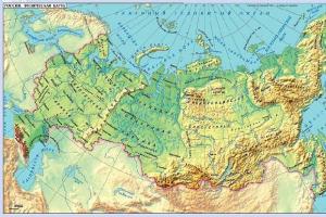
Rice. 1. East European Plain on the map.
The type of geological structure of the platform was formed under the influence of shields and fold belts.
It occupies second position in the ranking of sizes after the Amazonian Plain. The plain is located in the eastern part of Europe. Due to the fact that its main part is localized within the borders of Russia, the East European Plain is also called Russian. The Russian Plain is washed by the waters of the seas:
TOP 4 articleswho are reading along with this
- White;
- Barentsev;
- Black;
- Azovsky;
- Caspian.
The geographical position of the East European Plain is such that its length from north to south is more than 2.5 thousand kilometers, and from west to east - 1 thousand kilometers.
The geographical position of the plain determines the influence of the seas of the Atlantic and Arctic oceans on the specific nature of its nature. There is a full range of natural areas here - from tundra to deserts.
The features of the geological structure of the East European Platform are determined by the age of the rocks that make up the territory, among which the ancient Karelian folded crystalline basement is distinguished. Its age is over 1600 million years.
The minimum altitude of the territory is located on the coast of the Caspian Sea and is 26 m below sea level.
The predominant relief in this area is a gently sloping landscape.
Zoning of soils and flora is provincial in nature and is distributed in the direction from west to east.
The majority of Russia's population and the bulk of large settlements are concentrated on the flat territory. Interesting: It was here that the Russian state arose many centuries ago, which became the largest country in the world in terms of its territory.
On the East European Plain there are almost all types of natural zones that are characteristic of Russia.

Rice. 2. Natural areas of the East European Plain on the map.
Minerals of the East European Plain
There is a significant accumulation of Russian mineral resources here.
Natural resources that lie in the depths of the East European Plain:
- iron ore;
- coal;
- Uranus;
- non-ferrous metal ores;
- oil;
Natural monuments are protected areas containing unique objects of living or inanimate nature.
The main monuments of the East European Plain: Lake Seliger, Kivach Waterfall, Kizhi Museum-Reserve.

Rice. 3. Kizhi Museum-Reserve on the map.
A considerable part of the territory is allocated for agricultural land. Russian regions on the plain are actively using its potential and maximizing the exploitation of water and land resources. However, this is not always a good thing. The territory is highly urbanized and significantly altered by humans.
The level of pollution in many rivers and lakes has reached a critical level. This is especially noticeable in the center and south of the plain.
Protective measures are caused by uncontrolled human economic activity, which is today the main source of environmental problems.
The plain almost absolutely corresponds to the boundaries of the East European Platform.
This explains the flat appearance of the relief. Small hill-like formations within the East European Plain arose as a result of faults and other tectonic processes. This suggests that the plain has a tectonic structure.
Glaciation made its contribution to the formation of the flat relief.
The waterways of the plain are fed by snow, which occurs during the spring flood period. The high-water northern rivers flow into the White, Barents, and Baltic seas, and occupy 37.5% of the entire area of the plain. Inland water flow is determined by the seasonal nature of distribution, which occurs relatively evenly. During the summer season, rivers do not experience sudden shallowing.
What have we learned?
We found out what the total area of the East European Plain is. We found out which areas have the greatest water pollution as a result of human activity. We found out what natural monuments are located on the plain. We got an idea of the zonation of soils.
Test on the topic
Evaluation of the report
Average rating: 4.4. Total ratings received: 205.
The Russian Plain is also called the East European Plain. This is its physical-geographical name. The total area of this land area is 4 million km2. Only the Amazonian lowland is larger.
The East European Plain occupies a significant part of the territory of Russia. It starts off the coast of the Baltic Sea and ends near the Ural Mountains. From the north and from the south the plain is bordered by 2 seas at once. In the first case, these are the Barents and White Seas, in the second, the Caspian and Azov Seas. On different sides the plain is limited by mountain ranges. The situation is this:
- The northwestern border is the Scandinavian Mountains;
- Western and southwestern borders are the mountains of Central Europe and the Carpathians;
- Southern border - Caucasus Mountains;
- The eastern border is the Ural Mountains.
In addition, Crimea is located on the territory of the Russian Plain. In this case, the northern foothills of the Crimean Mountains act as the border.
Scientists have classified the East European Plain as a physical-geographical country due to the fact that it is characterized by the following features:
- Placement on one of the slabs of the same name plain of a platform, which, unlike the others, is slightly raised;
- Located in a temperate climate zone, as well as a small amount of precipitation. This is a consequence of the influence of two oceans, the first of which is the Atlantic, the second is the Arctic;
- The presence of a clear natural zonation, which is explained by the flatness of the relief.
The plain described is divided into two other plains, namely:
- Basement-denudation, occupying the Baltic crystalline shield;
- Eastern European, located on two plates at once: Scythian and Russian.
The crystalline shield has a unique relief. It was formed during continental denudation, which lasted more than one thousand years. Certain features were obtained by the relief as a result of tectonic movements that occurred in modern times. As for the past, in the Quaternary period the center of the glacier was located on the site of the modern Baltic crystalline shield. It is for this reason that the local terrain is glacial.
Platform deposits, which are part of the Russian Plain, represent a kind of cover, located in a horizontal position. Thanks to them, two types of hills and lowlands were formed. The first of them are formation-denudation, and the second are accumulative. In some areas of the plain there are projections of folded foundations. They are represented by basement-denudation hills and ridges: Donetsk, Timan, etc.
If we take into account the average statistical indicator, the height of the East European Plain above sea level is 170 meters. This indicator is lowest on the shores of the Caspian Sea, and highest on the hills. For example, the Podolsk Upland is located 417 meters above sea level.
Settlement of the East European Plain
Some scientists are of the opinion that Eastern Europe was inhabited by the Slavs, but some researchers are convinced of the opposite. It is known for certain that Cro-Magnons settled on the Russian Plain approximately 30 thousand years BC. Outwardly, they slightly resembled Caucasians, and over time they became similar to modern people. The process of adaptation of Cro-Magnons took place in glacier conditions. In the 10th millennium BC, the climate became milder, so the descendants of the Cro-Magnons, called Indo-Europeans, began to develop territories located in the southeast of modern Europe. Where they were before is unknown, but there is reliable evidence that the settlement of this territory by Indo-Europeans occurred 6 thousand years BC.
The first Slavs appeared on European territory much later than the Indo-Europeans. Historians claim that their active settlement dates back to the 5th-6th centuries AD. For example, the Balkan Peninsula and the adjacent territories were occupied by the South Slavs. The Western Slavs moved from north to west. Many of them became the ancestors of modern Germans and Poles. Some settled on the Baltic Sea coast, while others settled in the Czech Republic. At the same time, serious changes occurred in primitive society. In particular, the community became obsolete, the clan hierarchy faded into the background, and associations began to take their place, becoming the first states.
The Slavs, without any apparent difficulty, settled the eastern lands of a large territory called Europe. At first, their relations with each other were based on the primitive communal system, and later on the tribal system. The number of settlers was small, so their tribes did not lack free land.
During the settlement process, the Slavs assimilated with representatives of the Finno-Ugric tribes. Their inter-tribal unions are considered the first semblance of states. At the same time, the climate of Europe has become warmer. This led to the development of agriculture and cattle breeding, but at the same time fishing and hunting continued to play an important role in the economic activities of primitive people.
A favorable set of circumstances for the colonists explains that the Eastern Slavs became the largest group of peoples, including Russians, Ukrainians and Belarusians. If the settlement of the Slavs only began in the early Middle Ages, its “heyday” occurred in the 8th century. Simply put, it was at this time that the Slavic tribes were able to take a dominant position. Their neighbors were representatives of other nations. This has its pros and cons.
Speaking about the settlement of the Slavs, it should be noted that the main feature of this historical process is unevenness. First, the territories that were located near the route “from the Varangians to the Greeks” were developed, and only then the eastern, western and southwestern lands were colonized.
The settlement of the Slavs across the Russian Plain has a number of features. Among them it is necessary to highlight:
- Significant influence of climate on the duration of colonization;
- Dependence of population density on natural and climatic conditions. This means that the southern territories were populated more densely compared to the northern ones;
- The absence of military conflicts caused by a lack of land;
- Imposing tribute on other nations;
- Complete assimilation of representatives of small tribes.
After the Slavic tribes occupied the East European Plain, they began to develop new types of economic activity, made adjustments to the existing social system and created the preconditions for the creation of the first states.
Modern exploration of the East European Plain
Many famous scientists have studied the East European Plain. In particular, a huge contribution to the development of science was made by mineralologist V.M. Severgin.
In the early spring of 1803, Severgin was studying the Baltic states. While conducting research, he noticed that in the southwest direction from Lake Peipsi the terrain becomes more hilly. Subsequently, Vasily Mikhailovich made a multi-stage transition. First he walked from the Gauja River to the Neman, and then to the Bug. This allowed him to establish that the area was either hilly or elevated. Realizing that such an alternation is a pattern, Severgin unmistakably determined its direction, going from southwest to northeast.
The territory of Polesie was studied by scientists no less closely. In particular, numerous studies began after the lands on the right bank of the Dnieper “opened up”, which led to a decrease in the number of meadows. So, in 1873 the Western Expedition was organized. A group of scientists led by topographer I.I. Zhilinsky planned to study the characteristics of local swamps and determine the best ways to drain them. Over time, the expedition members were able to draw up a map of Polesie, studied lands with a total area of more than 100 thousand km2 and measured about 600 heights. The information obtained by Zhilinsky allowed A.A. Tillo will continue his colleague’s endeavors. This led to the appearance of the hypsometric map. It served as clear evidence that Polesie is a plain with elevated borders. In addition, it was found that this region is rich in rivers and lakes. There are approximately 500 of the former, and 300 of the latter. The total length of both exceeds 9 thousand kilometers.
Later, G.I. studied Polesie. Tanfilyev. He established that the destruction of swamps will not cause shallowing of the Dnieper. P.A. came to the same conclusion. Tutkovsky. The same scientist modified the map created by Tillo, adding several hills to it, among which the Ovruch Ridge should be highlighted.
E.P. Kovalevsky, being an engineer at one of the factories in Lugansk, devoted himself to studying the Donetsk Ridge. He conducted a lot of research and determined that the ridge is a pool of enormous size. Later, Kovalevsky was recognized as the discoverer of Donbass, because It was he who created his first geological map and suggested that the region was rich in minerals.
In 1840, the famous geologist R. Murchison came to Russia. Together with domestic scientists, he explored the coast of the White Sea. As a result of the work carried out, many rivers and hills were studied, which were later plotted on maps.
V.V. studied the southern part of the Russian Plain. Dokuchaev, who was later recognized as the “father” of Russian soil science. This scientist found that part of Eastern Europe is occupied by a unique zone, which is a mixture of black soil and steppe. In addition, in 1900, Dokuchaev drew up a map on which he divided the plain into 5 natural zones.
Over time, the interest of scientists in the East European Plain has not weakened. This led to the organization of many expeditions and various studies. Both of them allowed us to make many scientific discoveries, as well as create new maps.
The East European Plain, also often called the Russian Plain, is one of the largest plains on Earth. The length from west to east is about 2.4 thousand km, from north to south – 2.5 thousand km. In the north, the East European Plain is washed by the Barents and White Seas. In the west it borders on the Central European Plain (approximately along the Vistula River valley). In the southwest it approaches the mountains (Sudetes, etc.) and the Carpathians. In the south it reaches the Black, Azov and Caspian Seas and the Crimean Mountains and the Caucasus. In the southeast and east it is limited by the western foothills of the Urals and Mugodzhary.
The Russian Plain contains the European part, Lithuania, Estonia, Latvia, Belarus, Moldova, most of Ukraine, western Poland and eastern Kazakhstan.
Relief features and landscape
The relief is gently flat, formed as a result of faults in tectonic rocks. Based on relief features, the East European Plain can be divided into three stripes: central, southern and northern. In the center of the plain, vast hills and lowlands alternate with each other. In the north and south there are mainly lowlands with rare low altitudes.
Although the modern relief of the plain is of tectonic origin, there are no significant earthquakes here in our time. 
The East European Plain consists of hills with heights of 200-300 m above sea level and lowlands along which large rivers flow. The average height of the plain is 170 m, the highest at Bugulma-Belebeevskaya Upland 479 meters in the Urals part. Maximum mark Timan Ridge slightly less (471 m).
Highest part Russian Plain - northeastern. Here the average absolute height is about 400 m. As you approach the coastline of the Arctic Ocean, the terrain decreases. In the southern part, uplands often alternate with lowlands. And in the very south, in the Caspian zone, the lowland is at negative levels - 10-18 m below sea level.
(function(w, d, n, s, t) ( w[n] = w[n] || ; w[n].push(function() ( Ya.Context.AdvManager.render(( blockId: "R-A -256054-1", renderTo: "yandex_rtb_R-A-256054-1", async: true )); )); t = d.getElementsByTagName("script"); s = d.createElement("script"); s .type = "text/javascript"; s.src = "//an.yandex.ru/system/context.js"; s.async = true; t.parentNode.insertBefore(s, t); ))(this , this.document, "yandexContextAsyncCallbacks");
For the southern non-moraine region of the East European Plain characterized by large hills with erosive gully-gully relief (Volynskaya, Podolskaya, Pridneprovskaya, Priazovskaya, Central Russian, Privolzhskaya, Ergeni, Bugulminsko-Belebeevskaya, General Syrt, etc.) and outwash, alluvial accumulative lowlands and plains related to the region of the Dnieper glaciation (Pridneprovskaya , Oksko-Donskaya, etc.). Characterized by wide asymmetrical terraced river valleys.
In the southwest(Black Sea and Dnieper lowlands, Volyn and Podolsk uplands, etc.) loess and loess-like loams are found everywhere, from which flat watersheds with shallow steppe “saucers”, also called depressions, were formed.
In the northeast plains (High Trans-Volga region, General Syrt, etc.), where bedrock comes to the surface, watersheds are complicated by terraces, and the peaks are weathered remnants, the so-called shihans.
In the south and southeast– flat coastal accumulative lowlands (Black Sea, Azov, Caspian).
Age, formation theory and tectonic structure
At the base of the Russian Platform lies an ancient folded crystalline foundation, which is more than 1.5 billion years old. The foundation protrudes to the surface in the areas of the Baltic and Ukrainian shields; on the rest of its area there is a thick layer of sedimentary rocks dating back to Proterozoic before Cenozoic. The platform thickness varies from 35 to 55 km.
At the base of the East European Plain lie Russian stove with Precambrian crystalline basement and in the south the northern edge Scythian plate with a Paleozoic folded basement. The boundary between the plates is not expressed in the relief.
As a result of the shields coming to the surface, the Central Russian Upland and the Khibiny Mountains were formed. Not far from the Tsimlyansk Reservoir there is a significant geological anomaly, the so-called Main East European Fault.
Climate
The East European Plain is so large that it is located in 4 climatic and 8 natural zones. Climate zones:
- arctic;
- subarctic;
- moderate;
- subtropical.
Natural areas:
- arctic deserts;
- tundra;
- taiga;
- forests;
- forest-steppe;
- steppes;
- semi-deserts;
- deserts.
In the north from the Rybachy Peninsula to Yamal along the coast lies the Arctic desert. Winters in this zone are long and abnormally frosty. The temperature drops below -50°C. In summer it rarely gets above 10°C. During the year, the average temperature ranges from -10 to 0°C. Precipitation is more frequent in the warm season.
To the south, the Arctic desert turns into tundra and forest-tundra. Here the climate is slightly milder, and the average January temperature ranges from -10°C to -40°C. In July, the thermometer readings reach +11 - +14°C. Precipitation is 150 - 300 mm, but evaporation is low, which contributes to the formation of extensive wetlands.
Taiga-forest zone
 The taiga-forest zone occupies the largest part of the East European Plain (about 60% or almost 700 thousand sq. km) and requires a more detailed description. In this natural enclave, the climatic conditions can be described as moderate continental. The climate here is actively influenced by Arctic and Atlantic air masses.
Winter in the taiga-forest zone of the Russian Plain lasts from 5 to 6 months, depending on the distance from the Arctic. On average, the winter temperature scale is -10°C. When Arctic anticyclones invade (1–2 times a season), frosts reach anomalous levels of -30°C – -40°C. The thickness of the snow cover in the middle zone is 40–90 cm.
Spring begins at the end of March. The snow melts unstably and the process may continue until mid-April. Frosts are possible until the first ten days of June.
The average length of summer is three months. Summer temperatures are low, averaging +19°C. However, with the arrival of the Siberian and Central Asian anticyclones, it becomes hot: the thermometers exceed +19°C. Precipitation in summer falls quite often; the total summer norm is around 150 mm. This is about a third of the annual norm.
Autumn is usually quite short and rainy. The temperature is rarely higher than +9 - +11°C. From the end of October wet snow begins to fall. From the beginning of November the transition to winter begins.
Forest-steppe
 In the area of the 50th parallel, broad-leaved forests begin to give way to forest-steppes. They occupy about a quarter of the Russian Plain (150 thousand sq. km).
The climate type is also temperate, however, in this natural zone it is already much milder. Winter comes at the very end of November with the establishment of permanent snow cover. Winter cold fluctuates from -9°C to -15°C. Temperatures rarely reach low values. The snow cover can be up to 40 cm and completely disappears in March.
Spring is warm and short: it begins in April, and by the end of May summer weather has already set in. With the arrival of summer, precipitation increases significantly and in the first two months more than 60% of the annual average falls (from 300 to 600 mm). The temperature regime is much warmer than in the forests: the night temperature is +19°C, and during the day it soars to +36°C.
Summer ends in the second half of September.
Autumn lasts more than 2 months with fairly comfortable temperatures: the thermometer scale drops to zero only in mid-November.
Further south are the Russian steppes
In addition, the steppe zone is also present on. In relation to the previous natural zones, they occupy a small territory. 
The zone is located in the temperate zone, however, much warmer than all the previous ones. The duration of warm weather is six months or more. Winter lasts from December to March. In April, the warm spring weather is already stable. From mid-May the temperature rises to +30°C. Long and warm summers set in.
In summer, the thermometer rarely drops below +30°C. Summer turns into autumn only at the beginning of October. Moreover, above-zero temperatures last until mid-November. The transition to winter weather usually occurs in mid-December. There is little precipitation: only 150–300 mm falls during the year.
Semi-deserts and deserts
The East European Plain in its southeastern part covers two natural zones that are not quite typical for Russia: semi-deserts and deserts. 
Part of the following regions of Russia includes the following territories:
- Kalmykia
- Astrakhan
- Volgogradskaya
- Rostovskaya
These two natural enclaves are very similar to each other; they can only be divided very conditionally. The climate here is sharply continental and arid. The temperature regime and precipitation level are almost no different from the steppe zone. In deserts the amount of precipitation is 160 – 110 mm per year.
Dry subtropics are located on the territory of the Novorossiysk region and on the Crimean peninsula. The climate here is dry and hot. Winters are very warm and with high humidity. Precipitation amounts to more than 700 mm per year. 
The comparative analysis in the table shows how diverse the climate of the Russian Plain is:

Rivers and lakes
Most of the rivers of the East European Plain belong to the basins of the Atlantic and Arctic oceans.
Atlantic Ocean Basin:
- The Neva, Daugava (Zap. Dvina), Vistula, Neman and others flow into the Baltic Sea.
- The Dnieper, Dniester, and Yuzh flow into the Black Sea. Bug.
- To the Sea of Azov –, Kuban, etc.
Arctic Ocean Basin:
- Pechora flows into the Barents Sea.
- To the White Sea - Mezen, North. Dvina, Onega, etc.
The basin of internal flow, mainly of the Caspian Sea, includes (the largest river in Europe), Emba, Bolshoy Uzen, Maly Uzen, etc.
The rivers are fed mainly by melting snow. In the southwest, the river plains do not freeze every year; in the northeast, freeze-up lasts up to 8 months.
The hydrographic network has been significantly changed as a result of human economic activity. Systems of canals appeared (Volga-Baltic, White Sea-Baltic, etc.) that connect all the seas washing the East European Plain.
The flow of many rivers, especially those flowing to the south, is regulated. Significant sections of the Volga, Kama, Dnieper, and Dniester have been turned into cascades of reservoirs (Rybinskoye, Kuibyshevskoye, Tsimlyanskoye, Kremenchugskoye, Kakhovskoye, etc.).
Lakes are numerous and have different natures of origin:
- glacial-tectonic (Ladoga and - the largest in Europe),
- moraine (Chudsko-Pskovskoye, Ilmen, Beloye, etc.), etc.
- salt lakes (Baskunchak, Elton, Aralsor, Inder), formed by salt tectonics, i.e. some of them arose during the destruction of salt domes.
Flora
The East European Plain with its rich set of natural zones makes the flora of the region unique. All the vegetation characteristic of Russia grows here. The only exceptions may be plants growing in the highlands of the Caucasus and some samples of flora.
The poorest vegetation is naturally arctic desert and tundra. Mosses, lichens, and small shrubs have adapted to life in the extreme conditions of the subarctic climate. Vegetation covers, however, are not ubiquitous and are fragmentary.
With movement in forest-tundra rare bushes and herbaceous plants appear, and mosses are everywhere and cover the entire surface of the earth. Mosses form the basis of the reindeer's diet.
In the taiga zone a full range of coniferous species is presented: pine; spruce; larch; fir. The zone of mixed and deciduous forests, as well as the forest-steppe, are very similar in terms of plant life (including conifers). In different proportions, but each zone has the same plants: linden; ash; poplar; maple; oak; aspen.
In addition to tree crops from the taiga to the forest-steppe, Russian nature is rich in shrubs, both flowering and berry-bearing. A countless family of mushrooms hides in forests and shelterbelts throughout the warm season. The grass covers are represented by meadow and oak forest forbs.
Steppe zone has significant differences in vegetation. The basis is the zonal distribution of meadow steppe and forb or feather grass steppe. The steppe is filled with half a thousand species of herbaceous (flowering and non-flowering) plants. The Don Valley is famous for its huge water meadows. Semi-deserts have much sparse vegetation. Mainly feather grass and fescue. In addition, there are a number of subshrubs such as wormwood.
Herbaceous plants are represented by a small set of species that have adapted to seasonal existence: either they complete a full life cycle in one summer, or they are bulbous and persist until the next season (tulips, for example).
IN dry subtropics low-growing deciduous and evergreen shrubs grow. In deserts, only plants with a developed root system survive, which is able to hold them in weak soils and reach groundwater.
Fauna
The East European Plain is inhabited by animals of both western and eastern species. Tundra, forest, steppe and, to a lesser extent, desert animals are common here. Forest animals are the most widely represented. Western species of animals gravitate towards mixed and broad-leaved forests (pine marten, black polecat, hazel and garden dormouse, etc.). The western border of the range of some eastern animal species (chipmunk, weasel weasel, Ob lemming, etc.) passes through the taiga and tundra of the Russian Plain.
The fauna of the Russian Plain, more than any other part of the former USSR, has been changed by human intervention. The modern ranges of many animals are not determined by natural factors, but by human activity - hunting or changes in the habitat of animals (for example, deforestation).
Fur-bearing animals and ungulates suffered the most, the former because of their valuable fur, the latter because of their meat. River beaver, marten and squirrel were the main items of fur trade and trade among the Eastern Slavs in the 9th-13th centuries. Even then, a thousand years ago, the beaver was highly valued, and as a result of unregulated hunting, by the beginning of the 20th century, only a few individuals of this animal survived.
As a result of centuries of human economic activity, the fauna of the Russian Plain was greatly depleted. During the Soviet years, a lot of work was done to enrich the animal world: hunting is strictly regulated, reserves for the protection of rare animals were created, and re-acclimatization and acclimatization of valuable species is carried out.
A number of nature reserves have been created on the East European Plain. The most famous and important are Belovezhskaya Pushcha, Voronezh, Askania-Nova, Astrakhan. In the dense mixed forests of Belovezhskaya Pushcha (Western Belarus), bison are protected. In the Voronezh Nature Reserve, beavers were successfully bred in captivity for the first time in world practice. From here, from the Voronezh Nature Reserve, beavers are exported for reacclimatization to various regions of the former USSR.
The Askania-Nova steppe reserve (southern Ukraine) is known for its work on the acclimatization and hybridization of a wide variety of animals from Asia, Africa and even Australia. The reserve is under the jurisdiction of the All-Union Scientific Research Institute of Animal Acclimatization and Hybridization named after. M.F. Ivanov, whose employees bred valuable breeds of domestic sheep and pigs. The Astrakhan Nature Reserve was created in the Volga delta to protect waterfowl and fish spawning grounds.
Minerals
The East European Plain has a specific composition of fossils due to its geological structure. Here is the world's largest (more than 50% of world reserves) iron ore basin. Its capacity is estimated at 100 billion tons or more.

Mineral resources are represented by iron ores of the Kursk magnetic anomaly. The main ore here is magnetite, which occurs in Proterozoic quartzites. But now mainly ore deposits are being developed in the weathering crusts of the Precambrian basement enriched in iron oxides. The balance reserves of the Kursk magnetic anomaly are estimated at 31.9 billion tons, which is 57.3% of the country's iron ore reserves. The main part lies within the Kursk and Belgorod regions. The average iron content in ore exceeds the average for Russia and is 41.5%. Among the fields being developed are Mikhailovskoye (Kursk region) and Lebedinskoye, Stoilenskoye, Pogrometskoye, Gubkinskoye (Belgorod region). But the open method of ore mining has already led to the destruction of tens of thousands of hectares of land.
In the Belgorod region, reserves of bauxite with an alumina content of 20 to 70% have been explored (Vislovskoye deposit).
On the Russian Plain there are chemical raw materials: phosphorites (Kursk-Shchigrovsky basin, Yegoryevskoye deposit in the Moscow region and Polpinskoye in Bryansk), potassium salts (Verkhnekamsk basin, one of the largest in the world - contains a quarter of the world's potassium reserves, balance reserves in all categories are over 173 billion tons), rock salt (again the Verkhnekamsk basin, as well as the Iletsk deposit in the Orenburg region, Lake Baskunchak in the Astrakhan region and Elton in the Volgograd region).
Construction raw materials such as chalk, marls, cement raw materials, fine-grained sands are common in the Belgorod, Bryansk, Moscow, and Tula regions. A large deposit of high-quality cement marls is Volskoye in the Saratov region. The Tashlinskoye glass sand deposit in the Ulyanovsk region is a large raw material base for the entire glass industry in Russia and the CIS.
The Kiembaevskoye asbestos deposit is located in the Orenburg region. Quartz sands from the Dyatkovo (Bryansk region) and Gus-Khrustalnenskoye (Vladimir region) deposits are used for the production of artificial quartz, glass, and crystal glassware; kaolin clays from Konakova (Tver region) and Gzhel (Moscow region) are used in the porcelain and earthenware industry.
Reserves of hard and brown coal are concentrated in the Pechora, Donetsk and Moscow basins. Brown coals from the Moscow region are used not only as fuel, but also as chemical raw materials. Its role in the fuel and energy complex of the Central Federal District of Russia is increasing due to the high costs of importing energy resources from other regions of the country. Coal from the Moscow Region can also be used as a technological fuel for the region’s ferrous metallurgy.
Oil and gas are produced in a number of fields within the Volga-Ural (Samara region, Tatarstan, Udmurtia, Bashkortostan) and Timan-Pechora oil and gas regions. There are gas condensate fields in the Astrakhan region, and the Orenburg gas condensate field is the largest in the European part of the country (over 6% of all Russian gas reserves).
Deposits of oil shale are known in the Pskov and Leningrad regions, in the Middle Volga region (Kashpirovskoye deposit near Syzran) and in the northern part of the Caspian syneclise (Obsche-Syrtskoye deposit).