) OKATO code: 76254501
Based: 1st half 18th century
Urban settlement with: 1929
City from: 1951 City of district subordination (Shilkinsky district of Trans-Baikal Territory)
Center: Shilkinsky district Deviation from Moscow time, hours: 6
Geographic latitude: 51°51"
Geographical longitude: 116°02"
Altitude above sea level, meters: 490
Sunrise and sunset times in Shilka
Map
Shilka: photo from space (Google Maps)
Shilka: photo from space (Microsoft Virtual Earth)
| Shilka. Nearest cities. Distances in km. on the map (in brackets along roads) + direction. By hyperlink in the column distance you can get the route (information kindly provided by the AutoTransInfo website) |
|||
| 1 | Pervomaisky | 34 (32) | SW |
| 2 | 40 (39) | IN | |
| 3 | 50 (104) | SE | |
| 4 | Vershino-Darasunsky | 66 (72) | NW |
| 5 | Mogoituy | 99 (102) | SW |
| 6 | Chernyshevsk | 99 (131) | NE |
| 7 | Tin | 106 (162) | YU |
| 8 | Shelopugino | 108 (148) | IN |
| 9 | Verkh-Usugli | 110 () | NW |
| 10 | Yasnogorsk | 111 () | YU |
| 11 | Kokuy | 111 () | IN |
| 12 | Art. Clear | 115 () | YU |
| 13 | Karymskoye | 118 (128) | Z |
| 14 | 123 (135) | IN | |
a brief description of
The city is located in Transbaikalia, in the valley of the river. Shilka, 248 km east of Chita. Railway station. Road junction.
Near Shilka is the balneological resort Shivanda (which means “royal drink”). The first buildings of the resort were erected in 1899.
Territory (sq. km): 105
Information about the city of Shilka on the Russian Wikipedia site
Historical sketch
Founded in the first half of the 18th century. like the Cossack village of Shilka. In 1897, a railway ran through the village and a station village was formed.
Name by location on the river. Shilka. Evenki shilki means “narrow valley,” which is especially true for the lower reaches of the river, squeezed by steep mountain slopes.
Workers' settlement Shilka since 02/04/1929 City since 1951
Economy
Railway transport enterprises, a butter factory, a confectionery factory, a bakery, a reinforced concrete products factory and other enterprises.
In the Shilkinsky district, wheat, oats, rapeseed, corn, barley, potatoes, vegetables, and perennial herbs are grown. Cattle, sheep, and goats are raised. Poultry farming, beekeeping.
Deposits of ores, gold, molybdenum, rare earth metals, marble, coal, etc.
Main enterprises
NON-FERROUS METALLURGY
OJSC "Zabaikalsky GOK"673382, Transbaikal region, Shilkinsky district, Pervomaisky village, st. Mira, 18
Offers: Fluorspar, beryllium, lithium, tantalum concentrates, gold, zeolites
FOOD FLAVORS INDUSTRY
JSC "Onyx"673382, Trans-Baikal Territory, Shilkinsky district, Pervomaisky village, post office box 119
Offers: Mayonnaise, bakery products, pasta, confectionery, soft drinks
|
Flag of Shilka (city) |
Coat of arms of Shilka (city) |
| A country | Russia |
| Subject of the federation | Transbaikal region |
| Municipal district | Shilkinsky |
| Coordinates | Coordinates: 51°51′00″ N. w. 116°02′00″ E. d. / 51.85° n. w. 116.033333° E. d. (G) (O) (I)51°51′00″ n. w. 116°02′00″ E. d. / 51.85° n. w. 116.033333° E. d. (G) (O) (I) |
| Chapter | Nikiforova Natalya Grigorievna |
| Ethnobury | Shilkintsy, Shilkinets |
| City with | 1951 |
| Center height | 490 m |
| Postcode | 673370 |
| Population | ▼ 13,991 people (2010) |
| Telephone code | +7 30244 |
| Vehicle code | 75, 80 |
| Timezone | UTC+10 |
| OKATO code | 76 254 501 |
| Based | 1897 |
.png/11).png)
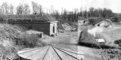
Railway station on the Trans-Siberian Railway.
Interesting fact
One of the verses of the song “Glorious Sea, Sacred Baikal...” begins with the words: “Shilka and Nerchinsk are not scary now...” This is apparently connected with a point that previously existed in Shilka for the transfer of prisoners.
Climate
- Average annual air temperature - 0.8 °C
- Average wind speed - 3.4 m/s
- Relative humidity - 61.9%
| Climate of Shilka | |||||||||||||
|---|---|---|---|---|---|---|---|---|---|---|---|---|---|
| Index | Jan | Feb | Mar | Apr | May | Jun | Jul | Aug | Sep | Oct | But I | Dec | Year |
| Average temperature, °C | 24,1 | 18,9 | 9,1 | 1,9 | 10,5 | 16,9 | 19,2 | 16,8 | 9,5 | 0,5 | 12,3 | 21,7 | 0,8 |
Mass media
Newspapers and magazines
- Newspaper "Shilkinskaya Pravda"
Story
The city owes its name to the Shilka River, known from the very beginning of the development of Transbaikalia by Russian explorers. The name “Silkar” in Evenki means a narrow valley, later in Russified form - Shilkar, and applied to the entire river from the source of the Onon River to the mouth of the Amur.
In 1897, the river flooded the administrative Cossack center, the village of Mitrofanovskaya, and destroyed the locomotive depot, station and pier, which had just begun to be built, where cargo arrived for the construction of the railway. Most of the Cossacks had to move to a new, higher place. On the haylands that belonged to the villages of Samsonovsky, Mitrofanovsky and Kazanovsky, a new village of Shilkinsky was formed. A station with a main locomotive depot with 6 stalls began to be built here. Construction was carried out by construction site 11, which had boundaries from the Onon-Nerchinsk station (now Priiskovaya) to the Verkhniye Klyuchi crossing. By the time the road was put into operation, the station had a main and three auxiliary tracks, two dead ends (now these are the tracks of the odd park). 2 depot buildings were built, three-line and single-line with hoods in both directions. Service and residential buildings were located in the area of modern Lenin and Stantsionnaya streets from the former railway club to the depot and in the northern part - along the current Sovetskaya, Kooperativnaya and Fizkulturnaya streets. According to the 1910 census, the inhabitants of the village were 1,652 souls of both sexes, of which 560 souls were railway employees and workers, 408 souls were Cossacks, 684 souls were commoners.
Here is a map of Shilki with streets → Zabaykalsky Krai, Russia. We study a detailed map of Shilka with house numbers and streets. Search in real time, weather today, coordinates
More details about Shilka streets on the map
A detailed map of the city of Shilka with street names can show all the routes and roads where the street is located. Balyabin and Tolstoy. Located near.
To view the territory of the entire region in detail, it is enough to change the scale of the online diagram +/-. On the page there is an interactive map of the city of Shilka with addresses and routes of the microdistrict. Move its center to now find Partizanskaya and Beregovaya streets.
The ability to plot a route across the country and calculate the distance using the “Ruler” tool, find out the length of the city and the path to its center, addresses of attractions, transport stops and hospitals (the “Hybrid” scheme type), look at train stations and borders.
You will find all the necessary detailed information about the location of the city's infrastructure - stations and shops, squares and banks, highways and highways.
An accurate satellite map of Shilka with Google search is in its own section. Use Yandex search to show the house number on the folk map of the city in the Trans-Baikal Territory of Russia/the world, in real time.
Shilkintsy, Shilkinets
Story
The city owes its name to the Shilka River, known from the very beginning of the development of Transbaikalia by Russian explorers. The name “Silkar” in Evenki means a narrow valley, later in Russified form - Shilkar, and applied to the entire river from the source of the Onon River to the mouth of the Amur.
In 1897, the river flooded the administrative Cossack center, the village of Mitrofanovskaya, and destroyed the locomotive depot, station and pier, which had just begun to be built, where cargo arrived for the construction of the railway. Most of the Cossacks had to move to a new, higher place. On the haylands that belonged to the villages of Samsonovsky, Mitrofanovsky and Kazanovsky, a new village of Shilkinsky was formed. A station with a main locomotive depot with 6 stalls began to be built here. Construction was carried out by construction site 11, which had boundaries from the Onon-Nerchinsk station (now Priiskovaya) to the Verkhniye Klyuchi crossing. By the time the road was put into operation, the station had a main and three auxiliary tracks, two dead ends (now these are the tracks of the odd park). 2 depot buildings were built, three-line and single-line with hoods in both directions. Service and residential buildings were located in the area of modern Lenin and Stantsionnaya streets from the former railway club to the depot and in the northern part - along the current Sovetskaya, Kooperativnaya and Fizkulturnaya streets. According to the 1910 census, the inhabitants of the village were 1,652 souls of both sexes, of which 560 souls were railway employees and workers, 408 souls were Cossacks, 684 souls were commoners.
After the CER and the Kaidalovskaya branch to it were put into operation in 1903, the main direction of the Transbaikal Railway became the Verkhneudinsk - Chita - Manchuria route. The Karymskaya - Sretensk section has become a dead end, its development, including the Shilka station, has slowed down. The book “Review of the commercial activities of the Trans-Baikal Railway for 1912” provides data on the station. The useful length of the station tracks, except for the main one, is 2486.98 linear fathoms (the same as in 1900). Warehouses and weighing equipment: warehouses - with an area of 25.90 square fathoms, with a capacity of 8 cars, covered platforms - with an area of 26.98 square meters. fathom with a capacity of 9 wagons, scales - one wagon and two decimal. Station staff: station chief, two assistants, commercial clerk, weigher. The main cargoes: upon arrival - grain, timber; on departure - hay, grain cargo, coal. In the area of the station (15 - 80 versts) there are gold mines of private owners Starnovsky, Kazakov, Polutov and others. The population near the mines is up to 5 thousand people.
At the end of 1913, through train traffic opened from Blagoveshchensk to St. Petersburg. The station became part of the Trans-Siberian Railway, and freight volumes increased sharply. And yet, the settlement of Shilka and the development of adjacent territories progressed slowly. In the village, the territory of the current Peace Square and Sotsgorod was used for haymaking, and there was still a swampy lake area. By 1923, its population was only 2,193 people.
The development of Shilka began in the second half of the 20s and, especially, in the 30s. Several factors contributed to this. Firstly, in 1926, an administrative reform was carried out in the country, a district and district division was introduced. Shilka became the center of a region formed from the Shilkinskaya and Razmakhninskaya volosts, and on January 9, 1929 it received the status of a workers' village. Secondly, emerging from devastation, the young Soviet country was forced to buy various materials and equipment from foreign countries. Gold was required. The gold mines of Baleya and Darasun began to develop. For the latter, Shilka became a transit point. Fuel, technical materials, equipment, and food were supplied to the growing mine and then the plant. Ore and concentrate were removed from the mine. An important factor in the subsequent development of the station was the construction of second tracks, which was carried out from 1932 to 1938. On December 5, 1933, a government decree was issued to strengthen the throughput and carrying capacity of the Trans-Baikal and Ussuri railways and staff the roads with engineering, technical and labor personnel. On the roads, it was planned to organize a network of technical railway schools with a three-year training period and factory schools. The NKPS FZU was created in Shilka; in 1934, 175 people were admitted to it, 134 people graduated. There was also a second training school here - mining apprenticeship.
The population of the village grew rapidly. If according to the 1926 census there were 3,663 people living in Shilka, then on January 1, 1931 - 5,818, on January 1, 1935 - 8,600 people. It was during these years that several locomotive depot buildings, a turntable and an overpass, an even station park, water supply from the Shilka River (before that there was a small water pumping station from the Kiya River), a station, a hospital, a school, a power plant, and a large residential area called Sotsgorod were built at the station. .
In 1932, the Shilkinskaya signaling and communication distance was organized within the boundaries of the Chinese crossing (Tarskaya) - Pashennaya station (Chernyshevsk), including branches to Nerchinsk, Sretensk, Bukachach. In the same year, the state farm DorURS was created, the first director of which was the locomotive depot driver D. A. Mogirev. In 1935, a carriage section was organized, the head of which was F.A. Monakhov. In 1936, the Shilka operational department was organized within the boundaries of Karymskaya - Ukurei. In 1939, a power plant with a capacity of 996 kW, built by AmurLAG, was put into operation. R.M. Brumer was appointed its first boss.
By the end of the 30s, Shilka became a powerful station with extensive track development and a full range of railway enterprises. The fact that its importance in the life of the railway has grown is evidenced by the fact that in March 1939, Anton Kolbin, a blacksmith of the Shilkinsky locomotive depot, was elected as a delegate to the XVIII Party Congress from the Transbaikal railway workers. These are some little-known pages of the history of the station and the city of Shilka.
Climate
- Average annual air temperature - −0.8 °C
- Relative humidity - 61.9%
- Average wind speed - 3.4 m/s
| Climate of Shilka | |||||||||||||
|---|---|---|---|---|---|---|---|---|---|---|---|---|---|
| Index | Jan | Feb | Mar | Apr | May | Jun | Jul | Aug | Sep | Oct | But I | Dec | Year |
| Average temperature, °C | −24,1 | −18,9 | −9,1 | 1,9 | 10,5 | 16,9 | 19,2 | 16,8 | 9,5 | 0,5 | −12,3 | −21,7 | −0,8 |
| Source: NASA RETScreen Database | |||||||||||||
Education and science
Schools:
- Secondary School No. 1
- Secondary school No. 2
- Secondary School No. 51
- Secondary school No. 52
Schools:
- PU-16
Famous people
The writer P.K. Rozhnova was born in Shilka.
mass media
Interesting fact
One of the verses of the song “Glorious Sea, Sacred Baikal...” begins with the words: “Shilka and Nerchinsk are not scary now...” This is apparently connected with a point that previously existed in Shilka for the transfer of prisoners.
Literature
- Shilkinsky district of the Trans-Baikal Territory, Novosibirsk, publishing house "Nauka".
- Oleg Sergeevich Kozhin, Shilkinsky district from ancient times to the present day: Geography, geology, history of development, research, Express Publishing House (Chita, 2007).
Notes
Links

Administrative center: Chita
Cities: Balei | Borzya | Krasnokamensk | Mogocha | Nerchinsk | Petrovsk-Zabaikalsky | Sretensk | Khilok | Shilka
Municipal districts:
The city of Shilka is located on the territory of the state (country) Russia, which in turn is located on the territory of the continent Europe.Which federal district does the city of Shilka belong to?
The city of Shilka is part of the federal district: Siberian.The Federal District is an enlarged territory consisting of several constituent entities of the Russian Federation.
In what region is the city of Shilka located?
The city of Shilka is part of the Trans-Baikal Territory region.A characteristic of a region or a subject of a country is the integrity and interconnection of its constituent elements, including cities and other settlements that are part of the region.
The Trans-Baikal Territory region is an administrative unit of the state of Russia.