3. Find the five oceans of the Earth on the globe and write their names. Label them with numbers on the globe drawings.
1. Arctic Ocean.
2. Atlantic Ocean.
3. Indian Ocean.
4. Pacific Ocean.
5. Southern Ocean.
4. Read the text. Use a globe to determine and write which oceans we are talking about.
1. The shores of Antarctica are washed by the Southern Ocean.
2. An ocean that is entirely in the Northern Hemisphere is Arctic.
3. Oceans through which the equator passes: Pacific, Atlantic, Indian.
5. Find the continents on the globe and write their names in the sentences.
1. The continent on which our country, Russia, is located is called Eurasia.
2. The equator crosses continents: South America, Africa.
6. Read the statements. Check their correctness using a globe. If the statement is correct, write “yes”.
The Arctic Ocean is located in the Northern Hemisphere. Yes
The South Pole is located on the continent of South America. No
It is not enough just to know what a globe is. You need to learn how to read it correctly in order to learn a lot of new and interesting things. In this lesson we will learn what the colors on the globe mean. Let's learn the names of the oceans and continents, talk about their features and differences. Let's get acquainted with the amazing wonders of nature, flora and fauna.
Why are there the most blue and cyan colors on the globe? Most of the earth's surface is covered with water. In a photograph taken from space, all areas of water appear blue. This color on the globe indicates oceans and seas, rivers and lakes.

Rice. 2. Earth from space ()
But if you look closely, you will notice that in different places the ocean is indicated by different shades. This is done to show depth: the deeper the ocean, the darker the blue color, and the shallower the depth, the lighter the paint on the globe. - these are huge expanses of bitterly salty water that surround continents and islands.

Pacific Ocean- the largest on Earth.

Rice. 4. Physical map of the Pacific Ocean ()
The navigator Ferdinand Magellan gave it this name because during his journey on sailing ships this ocean was calm. Although in fact the Pacific Ocean is not quiet at all, especially in its western part, where it raises and drives huge waves - tsunami, bringing a lot of trouble to the inhabitants of the Japanese islands.

Mariana Trench- the deepest place in the world. It is located in the Pacific Ocean, its depth is eleven kilometers and thirty-four meters.

Rice. 6. Mariana Trench ()
Previously, Europeans did not even suspect the existence of the Pacific Ocean. They knew only one ocean - Atlantic, which seemed limitless, so it was named after the most powerful hero of Greek myths, Atlas.

Rice. 7. Physical map of the Atlantic Ocean ()
In fact, the Atlantic Ocean is the second largest after the Pacific Ocean, the greatest depth of the ocean is 5 kilometers. In the Atlantic Ocean there are huge waves as high as a three-story house.
Indian Ocean It is especially restless in its southern part. It is warmer than others; even in the northern part of the Indian Ocean, the waters warm up to + 35 degrees.

Rice. 8. Physical map of the Indian Ocean ()
Arctic- the northernmost region, covered in winter and summer with a thick layer of ice and snow. There is a fourth ocean near the North Pole, almost its entire surface is covered with thick, strong ice, and there are multi-meter snowdrifts around. That's why this ocean was named Arctic.

Rice. 9. Physical map of the Arctic Ocean
Relatively recently, oceanographers began to identify a fifth, South ocean.

Rice. 10. Physical map of Antarctica ()
Previously, this ocean was considered to be the southern parts of the Indian, Atlantic and Pacific oceans. All oceans together: Pacific, Indian, Atlantic, Arctic and Southern - merge together into one world Ocean, which washes the entire globe.
On the globe, large areas of land called continents are depicted in green, yellow, brown and white. On the ground six continents: Eurasia, Africa, Australia, Antarctica, North America, South America.
Eurasia- the largest continent, within its borders lie two parts of the world: Europe and Asia.

Rice. 11. Physical map of Eurasia ()
It is the only continent on Earth washed by four oceans: the Arctic in the north, the Indian in the south, the Atlantic in the west and the Pacific in the east. Our homeland is located on this continent Russia.

Rice. 12. Russia on the map of Eurasia ()
The surface of the continent is very diverse. Mountains and plains are the main forms of the earth's surface. Brown indicates the location of mountains, while green and yellow indicate plains. The largest of them West Siberian(flat plain) Eastern European(hilly plain).

Rice. 13. West Siberian Plain ()

Rice. 14. Physical map of the East European Plain ()
Rivers are indicated on the globe by uneven blue lines drawn along the surface of the continents. Rivers flow across the East European Plain Volga, Don, Dnieper, a river flows across the West Siberian Plain Ob. Mountains rise above the surface of the plains. The higher the mountains, the darker their color on the globe. Himalayas are the highest mountains in the world.

Rice. 15. Himalaya mountains ()
Jamalungma (Everest)- the highest mountain in the world (8 km 708 m).

Rice. 16. Mount Jamalungma ()
Located in Eurasia Baikal- the deepest lake,

Rice. 17. Lake Baikal ()
The largest lake

Rice. 18. Caspian Sea ()
largest peninsula Arabian,

Rice. 19. Coast of the Arabian Peninsula ()
lowest point of land in the world - depression Dead Sea.

Rice. 20. Dead Sea ()

Rice. 21. Pole of Cold Oymyakon ()
Africa is the second largest continent, which is located on both sides of the equator, washed by the Atlantic Ocean from the west and the Indian Ocean from the east and south.

Rice. 22. Physical map of Africa ()
Africa is known for its diversity of nature: impenetrable tropical forests with orchids,

Rice. 23. Rainforest ()
grassy plains with baobabs (huge trees up to forty meters in circumference),

vast expanses of desert.

Rice. 25. Desert in Africa ()
Africa is the hottest continent on the planet. Here it is Sahara Desert.

Rice. 26. Sahara Desert ()
It is the largest desert in the world and the hottest place on Earth (the maximum recorded temperature is +58 degrees). On this continent flows Nile- the second longest river in the world.

Rice. 27. River Nile ()
Volcano Kilimanjaro- the highest point in Africa.

Rice. 28. Mount Kilimanjaro ()
Victoria, Tanganyika, Chad- the largest lakes on this continent.

Rice. 29. Lake Victoria ()

Rice. 30. Lake Tanganyika ()

Rice. 31. Lake Chad ()
In the Western Hemisphere are North America And South America, they are washed from the west by the Pacific Ocean, from the east by the Atlantic, and North America is also washed by the Arctic Ocean from the north.

Rice. 32. Physical map of North America

Rice. 33. Physical map of South America
North America also includes the largest island on Earth, it is called Greenland.

Rice. 34. Coast of Greenland ()
These continents are rich in rivers and lakes. North America is home to one of the world's greatest rivers Mississippi,

Rice. 35. Mississippi River ()
and in South America there is a river that is the largest in the world in terms of depth and length.

Rice. 36. Amazon ()
There is a bay on the coast of North America Fundy, which, in addition to its incredible beauty, is famous for the largest tides in the world, more than seventeen meters.

Rice. 37. Bay of Fundy ()
Just imagine, millions of tons of water approach the shore in twelve hours and then move away from it. South America is home to the world's tallest waterfall - Angel, its total height is 979 meters.

Rice. 38. Angel Falls ()
It seems as if it is shrouded in fog - a curtain of tiny particles of water that is sprayed, falling from such a great height. The most powerful waterfall in the world is located on the same continent Iguazu.

Rice. 39. Iguazu Falls ()
Although in fact it is a whole complex of 270 individual waterfalls, which is about 2.7 km wide. South America is home to the driest place in the world - the desert. Atacama.

Rice. 40. Atacama Desert ()
In some places in this desert, rain falls once every few decades.
Australia- the fifth continent, which is smaller than all the others. The Pacific Ocean washes the northern and eastern coasts, the Indian Ocean washes the western and southern coasts.

Rice. 41. Physical map of Australia
Most of the continent is occupied by deserts and semi-deserts, there are very few rivers, which is why Australia is considered the driest continent on Earth. Common here screams(English creek - rivulet) - rivers that exist only during the rainy season and completely dry up for most of the year.
It is not enough just to know what a globe is. You need to learn how to read it correctly in order to learn a lot of new and interesting things. In this lesson we will learn what the colors on the globe mean. Let's learn the names of the oceans and continents, talk about their features and differences. Let's get acquainted with the amazing wonders of nature, flora and fauna.
Why are there the most blue and cyan colors on the globe? Most of the earth's surface is covered with water. In a photograph taken from space, all areas of water appear blue. This color on the globe indicates oceans and seas, rivers and lakes.
Rice. 2. Earth from space ()
But if you look closely, you will notice that in different places the ocean is indicated by different shades. This is done to show depth: the deeper the ocean, the darker the blue color, and the shallower the depth, the lighter the paint on the globe. - these are huge expanses of bitterly salty water that surround continents and islands.
Pacific Ocean- the largest on Earth.
Rice. 4. Physical map of the Pacific Ocean ()
The navigator Ferdinand Magellan gave it this name because during his journey on sailing ships this ocean was calm. Although in fact the Pacific Ocean is not quiet at all, especially in its western part, where it raises and drives huge waves - tsunami, bringing a lot of trouble to the inhabitants of the Japanese islands.
Mariana Trench- the deepest place in the world. It is located in the Pacific Ocean, its depth is eleven kilometers and thirty-four meters.
Rice. 6. Mariana Trench ()
Previously, Europeans did not even suspect the existence of the Pacific Ocean. They knew only one ocean - Atlantic, which seemed limitless, so it was named after the most powerful hero of Greek myths, Atlas.
Rice. 7. Physical map of the Atlantic Ocean ()
In fact, the Atlantic Ocean is the second largest after the Pacific Ocean, the greatest depth of the ocean is 5 kilometers. In the Atlantic Ocean there are huge waves as high as a three-story house.
Indian Ocean It is especially restless in its southern part. It is warmer than others; even in the northern part of the Indian Ocean, the waters warm up to + 35 degrees.
Rice. 8. Physical map of the Indian Ocean ()
Arctic- the northernmost region, covered in winter and summer with a thick layer of ice and snow. There is a fourth ocean near the North Pole, almost its entire surface is covered with thick, strong ice, and there are multi-meter snowdrifts around. That's why this ocean was named Arctic.
Rice. 9. Physical map of the Arctic Ocean
Relatively recently, oceanographers began to identify a fifth, South ocean.
Rice. 10. Physical map of Antarctica ()
Previously, this ocean was considered to be the southern parts of the Indian, Atlantic and Pacific oceans. All oceans together: Pacific, Indian, Atlantic, Arctic and Southern - merge together into one world Ocean, which washes the entire globe.
On the globe, large areas of land called continents are depicted in green, yellow, brown and white. On the ground six continents: Eurasia, Africa, Australia, Antarctica, North America, South America.
Eurasia- the largest continent, within its borders lie two parts of the world: Europe and Asia.
Rice. 11. Physical map of Eurasia ()
It is the only continent on Earth washed by four oceans: the Arctic in the north, the Indian in the south, the Atlantic in the west and the Pacific in the east. Our homeland is located on this continent Russia.
Rice. 12. Russia on the map of Eurasia ()
The surface of the continent is very diverse. Mountains and plains are the main forms of the earth's surface. Brown indicates the location of mountains, while green and yellow indicate plains. The largest of them West Siberian(flat plain) Eastern European(hilly plain).
Rice. 13. West Siberian Plain ()
Rice. 14. Physical map of the East European Plain ()
Rivers are indicated on the globe by uneven blue lines drawn along the surface of the continents. Rivers flow across the East European Plain Volga, Don, Dnieper, a river flows across the West Siberian Plain Ob. Mountains rise above the surface of the plains. The higher the mountains, the darker their color on the globe. Himalayas are the highest mountains in the world.
Rice. 15. Himalaya mountains ()
Jamalungma (Everest)- the highest mountain in the world (8 km 708 m).
Rice. 16. Mount Jamalungma ()
Located in Eurasia Baikal- the deepest lake,
Rice. 17. Lake Baikal ()
The largest lake
Rice. 18. Caspian Sea ()
largest peninsula Arabian,
Rice. 19. Coast of the Arabian Peninsula ()
lowest point of land in the world - depression Dead Sea.
Rice. 20. Dead Sea ()
Rice. 21. Pole of Cold Oymyakon ()
Africa is the second largest continent, which is located on both sides of the equator, washed by the Atlantic Ocean from the west and the Indian Ocean from the east and south.
Rice. 22. Physical map of Africa ()
Africa is known for its diversity of nature: impenetrable tropical forests with orchids,
Rice. 23. Rainforest ()
grassy plains with baobabs (huge trees up to forty meters in circumference),
vast expanses of desert.
Rice. 25. Desert in Africa ()
Africa is the hottest continent on the planet. Here it is Sahara Desert.
Rice. 26. Sahara Desert ()
It is the largest desert in the world and the hottest place on Earth (the maximum recorded temperature is +58 degrees). On this continent flows Nile- the second longest river in the world.
Rice. 27. River Nile ()
Volcano Kilimanjaro- the highest point in Africa.
Rice. 28. Mount Kilimanjaro ()
Victoria, Tanganyika, Chad- the largest lakes on this continent.
Rice. 29. Lake Victoria ()
Rice. 30. Lake Tanganyika ()
Rice. 31. Lake Chad ()
In the Western Hemisphere are North America And South America, they are washed from the west by the Pacific Ocean, from the east by the Atlantic, and North America is also washed by the Arctic Ocean from the north.
Rice. 32. Physical map of North America
Rice. 33. Physical map of South America
North America also includes the largest island on Earth, it is called Greenland.
Rice. 34. Coast of Greenland ()
These continents are rich in rivers and lakes. North America is home to one of the world's greatest rivers Mississippi,
Rice. 35. Mississippi River ()
and in South America there is a river that is the largest in the world in terms of depth and length.
Rice. 36. Amazon ()
There is a bay on the coast of North America Fundy, which, in addition to its incredible beauty, is famous for the largest tides in the world, more than seventeen meters.
Rice. 37. Bay of Fundy ()
Just imagine, millions of tons of water approach the shore in twelve hours and then move away from it. South America is home to the world's tallest waterfall - Angel, its total height is 979 meters.
Rice. 38. Angel Falls ()
It seems as if it is shrouded in fog - a curtain of tiny particles of water that is sprayed, falling from such a great height. The most powerful waterfall in the world is located on the same continent Iguazu.
Rice. 39. Iguazu Falls ()
Although in fact it is a whole complex of 270 individual waterfalls, which is about 2.7 km wide. South America is home to the driest place in the world - the desert. Atacama.
Rice. 40. Atacama Desert ()
In some places in this desert, rain falls once every few decades.
Australia- the fifth continent, which is smaller than all the others. The Pacific Ocean washes the northern and eastern coasts, the Indian Ocean washes the western and southern coasts.
Rice. 41. Physical map of Australia
Most of the continent is occupied by deserts and semi-deserts, there are very few rivers, which is why Australia is considered the driest continent on Earth. Common here screams(English creek - rivulet) - rivers that exist only during the rainy season and completely dry up for most of the year.
Continents and oceans on the globe
The planet we live on
It is not enough just to know what a globe is. You need to learn how to read it correctly in order to learn a lot of new and interesting things. In this lesson we will learn what the colors on the globe mean. Let's learn the names of the oceans and continents, talk about their features and differences. Let's get acquainted with the amazing wonders of nature, flora and fauna.
Look closely at the globe. It has many colors: blue, cyan, green, yellow, brown and white. This is done in order to tell us as much as possible about the Earth.
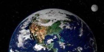
Why are there the most blue and cyan colors on the globe? Most of the earth's surface is covered with water. In a photograph taken from space, all areas of water appear blue. This color on the globe indicates oceans and seas, rivers and lakes.
Rice. 2. Earth from space ()
But if you look closely, you will notice that in different places the ocean is indicated by different shades. This is done to show depth: the deeper the ocean, the darker the blue color, and the shallower the depth, the lighter the paint on the globe. - these are huge expanses of bitterly salty water that surround continents and islands.
Pacific Ocean- the largest on Earth.
Rice. 4. Physical map of the Pacific Ocean ()
The navigator Ferdinand Magellan gave it this name because during his journey on sailing ships this ocean was calm. Although in fact the Pacific Ocean is not quiet at all, especially in its western part, where it raises and drives huge waves - tsunami, bringing a lot of trouble to the inhabitants of the Japanese islands.
Mariana Trench- the deepest place in the world. It is located in the Pacific Ocean, its depth is eleven kilometers and thirty-four meters.
Rice. 6. Mariana Trench ()
Previously, Europeans did not even suspect the existence of the Pacific Ocean. They knew only one ocean - Atlantic, which seemed limitless, so it was named after the most powerful hero of Greek myths, Atlas.
Rice. 7. Physical map of the Atlantic Ocean ()
In fact, the Atlantic Ocean is the second largest after the Pacific Ocean, the greatest depth of the ocean is 5 kilometers. In the Atlantic Ocean there are huge waves as high as a three-story house.
Indian Ocean It is especially restless in its southern part. It is warmer than others; even in the northern part of the Indian Ocean, the waters warm up to + 35 degrees.
Rice. 8. Physical map of the Indian Ocean ()
Arctic- the northernmost region, covered in winter and summer with a thick layer of ice and snow. There is a fourth ocean near the North Pole, almost its entire surface is covered with thick, strong ice, and there are multi-meter snowdrifts around. That's why this ocean was named Arctic.
Rice. 9. Physical map of the Arctic Ocean
Relatively recently, oceanographers began to identify a fifth, South ocean.
Rice. 10. Physical map of Antarctica ()
Previously, this ocean was considered to be the southern parts of the Indian, Atlantic and Pacific oceans. All oceans together: Pacific, Indian, Atlantic, Arctic and Southern - merge together into one world Ocean, which washes the entire globe.
On the globe, large areas of land called continents are depicted in green, yellow, brown and white. On the ground six continents: Eurasia, Africa, Australia, Antarctica, North America, South America.
Eurasia- the largest continent, within its borders lie two parts of the world: Europe and Asia.
Rice. 11. Physical map of Eurasia ()
It is the only continent on Earth washed by four oceans: the Arctic in the north, the Indian in the south, the Atlantic in the west and the Pacific in the east. Our homeland is located on this continent Russia.
Rice. 12. Russia on the map of Eurasia ()
The surface of the continent is very diverse. Mountains and plains are the main forms of the earth's surface. Brown indicates the location of mountains, while green and yellow indicate plains. The largest of them West Siberian(flat plain) Eastern European(hilly plain).
Rice. 13. West Siberian Plain ()
Rice. 14. Physical map of the East European Plain ()
Rivers are indicated on the globe by uneven blue lines drawn along the surface of the continents. Rivers flow across the East European Plain Volga, Don, Dnieper, a river flows across the West Siberian Plain Ob. Mountains rise above the surface of the plains. The higher the mountains, the darker their color on the globe. Himalayas are the highest mountains in the world.
Rice. 15. Himalaya mountains ()
Jamalungma (Everest)- the highest mountain in the world (8 km 708 m).
Rice. 16. Mount Jamalungma ()
Located in Eurasia Baikal- the deepest lake,
Rice. 17. Lake Baikal ()
The largest lake
Rice. 18. Caspian Sea ()
largest peninsula Arabian,
Rice. 19. Coast of the Arabian Peninsula ()
lowest point of land in the world - depression Dead Sea.
Rice. 20. Dead Sea ()
Rice. 21. Pole of Cold Oymyakon ()
Africa is the second largest continent, which is located on both sides of the equator, washed by the Atlantic Ocean from the west and the Indian Ocean from the east and south.
Rice. 22. Physical map of Africa ()
Africa is known for its diversity of nature: impenetrable tropical forests with orchids,
Rice. 23. Rainforest ()
grassy plains with baobabs (huge trees up to forty meters in circumference),
vast expanses of desert.
Rice. 25. Desert in Africa ()
Africa is the hottest continent on the planet. Here it is Sahara Desert.
Rice. 26. Sahara Desert ()
It is the largest desert in the world and the hottest place on Earth (the maximum recorded temperature is +58 degrees). On this continent flows Nile- the second longest river in the world.
Rice. 27. River Nile ()
Volcano Kilimanjaro- the highest point in Africa.
Rice. 28. Mount Kilimanjaro ()
Victoria, Tanganyika, Chad- the largest lakes on this continent.
Rice. 29. Lake Victoria ()
Rice. 30. Lake Tanganyika ()
Rice. 31. Lake Chad ()
In the Western Hemisphere are North America And South America, they are washed from the west by the Pacific Ocean, from the east by the Atlantic, and North America is also washed by the Arctic Ocean from the north.
Rice. 32. Physical map of North America
Rice. 33. Physical map of South America
North America also includes the largest island on Earth, it is called Greenland.
Rice. 34. Coast of Greenland ()
These continents are rich in rivers and lakes. North America is home to one of the world's greatest rivers Mississippi,
Rice. 35. Mississippi River ()
and in South America there is a river that is the largest in the world in terms of depth and length.
Rice. 36. Amazon ()
There is a bay on the coast of North America Fundy, which, in addition to its incredible beauty, is famous for the largest tides in the world, more than seventeen meters.
Rice. 37. Bay of Fundy ()
Just imagine, millions of tons of water approach the shore in twelve hours and then move away from it. South America is home to the world's tallest waterfall - Angel, its total height is 979 meters.
Rice. 38. Angel Falls ()
It seems as if it is shrouded in fog - a curtain of tiny particles of water that is sprayed, falling from such a great height. The most powerful waterfall in the world is located on the same continent Iguazu.
Rice. 39. Iguazu Falls ()
Although in fact it is a whole complex of 270 individual waterfalls, which is about 2.7 km wide. South America is home to the driest place in the world - the desert. Atacama.
Rice. 40. Atacama Desert ()
In some places in this desert, rain falls once every few decades.
Australia- the fifth continent, which is smaller than all the others. The Pacific Ocean washes the northern and eastern coasts, the Indian Ocean washes the western and southern coasts.
Rice. 41. Physical map of Australia
Most of the continent is occupied by deserts and semi-deserts, there are very few rivers, which is why Australia is considered the driest continent on Earth. Common here screams(English creek - rivulet) - rivers that exist only during the rainy season and completely dry up for most of the year.

Rice. 42. Dry river mouth (