Where is the Arctic and Antarctic located? And how do these regions of the Earth differ from each other? This question puzzles many people, even if they studied geography conscientiously in school. Our article will help answer it.
The difference between the Arctic and Antarctica
A fairly popular one is: “Do polar bears eat penguins?” The brain of an adult immediately begins to build a logical chain of thought. Pictures from school textbooks pop up in my memory, where both animals are depicted against the background. eternal ice and harsh winter landscapes. A man argues like this: polar bears are predators, and penguins are rather clumsy birds, easy prey. Therefore, the former should gladly feast on the latter.
However, it's not like that at all! Not everyone will guess that these animals in the wild cannot meet at all, as they live in completely different parts of the world. One of them is the Arctic and the other is the Antarctic. Therefore, they can only see each other in some zoo.
Where is the Arctic and Antarctica - about this and will be discussed Further. What are the features of nature, climate and the organic world of these areas?
Where is the Arctic located? Brief description of the area
What is the difference between the Arctic, Antarctica and Antarctica? Let's try to understand this geographical issue.
Where is the Arctic located on the globe? In what part of the world should you look for it?
At the very beginning, you need to remember that our planet Earth has two poles that are diametrically opposed to each other - North and South. This will help you better navigate where the Arctic is and where the Antarctic is.
So, the Arctic is the polar region of the Earth, directly adjacent to its North Pole. Geographically, it covers the ends of the Pacific and Atlantic Oceans. The Arctic also includes the outskirts of Eurasia and North America, as well as numerous islands.

Sometimes this physiographic macro-region is limited from the south. The area of the region, depending on the location of its southern borders, ranges from 21 to 27 million square kilometers.
Now you know where the Arctic is. What was the development of it by man? And when did it start?
The history of the conquest of the Arctic and the North Pole
The Arctic has been inhabited for a long time. This is evidenced by numerous archaeological finds. So, man first appeared on the shores of the Arctic Ocean 30 thousand years ago. However, later it began to pull further north. There were also daredevils who wished to conquer the pole of the Earth.
Serious and systematic study of the area began in the second half of the 19th century. The most famous polar explorer of that time is the Norwegian Fridtjof Nansen. In particular, he went down in history by being the first to be able to cross the ice shell of Greenland, the largest island on the planet. It happened in 1889.
Robert Peary is another important name in history. In 1908-1909, he organized an expedition that reached the North Pole for the first time. Interestingly, the goal of this trip was only this record. None scientific research expedition did not take place.

7 Surprising Facts About the Arctic
The Arctic is an amazing region that is full of secrets, mysteries and unusual natural phenomena. Below are the most interesting facts about him:
- The organic world of the Arctic, despite such a harsh climate, is quite rich. Huge ice spaces are densely populated by polar bears, arctic foxes, lemmings, reindeer, dozens of bird species and other animals. You can even meet an ordinary crow here!
- Five states immediately claim their rights to the Arctic, including Russia;
- The Arctic shelf, according to rough estimates of scientists, hides over 100 billion tons of gas and oil;
- About 50 million years ago, the climate of the Arctic was much milder. The water in the Arctic Ocean in those days warmed up in summer to + 15 ... 18 degrees!
- The Arctic is the region of the Earth that is most vulnerable to global processes global warming;
- There are deserts not only in the tropical zone, but also in the Arctic. Only here they are called arctic;
- The very first voyage across Arctic waters was made by ancient greek Pytheas as early as the 4th century BC.
Antarctica and Antarctica - where are they located?
Geographers call Antarctica the southern circumpolar region of the Earth, which is located on the opposite side of the planet from the Arctic. It includes a huge landmass - the mainland Antarctica, as well as the southern extremities of the Pacific, Atlantic and Indian Oceans (many foreign scientists also distinguish the fifth ocean of the Earth - the South) in this area.
The northern border of Antarctica is rather conditional. Most often it is carried out along the edge of the floating ice zone (between 50-55 degrees south latitude). Thus, the total area of the Antarctic is much larger than the Arctic, and is about 60 million square kilometers.
Antarctica, as mentioned above, is the sixth continent of the planet Earth - the southernmost and coldest.
The history of the discovery and development of Antarctica
Already in the 18th century, people assumed that there was another continent in the south of our planet. James Cook was the first to search for it in 1775. During his circumnavigation he came close to the mysterious "Southern Land", discovering the South Sandwich Islands.
The discovery of the mainland of Antarctica took place in 1820 during the expedition of Russian navigators F. Bellingshausen and M. P. Lazarev. After that, a series of discoveries and mapping of various seas, islands and lands in Antarctica began.
In 1911, two expeditions at once (one led by Roald Amundsen, the other by Robert Scott) set off to conquer South Pole Earth. But luck smiled at only one of the groups of desperate daredevils. On December 14, 1911, Amundsen planted the Norwegian flag at the Pole. Scott's group reached the goal of the expedition 27 days later, and all of its members died on the way back.

The continent of Antarctica has a significant mineral resource potential. However, the countries of the world signed an agreement on the "inviolability" of the bowels of the continent until 2048.
7 amazing facts about Antarctica
We bring to your attention 7 interesting facts about Antarctica and Antarctica:
- Antarctica is the coldest continent on the planet. In the 80s, the lowest temperature on Earth (-89 degrees) was recorded at the Soviet Vostok polar station;
- Antarctica is also the highest continent on the planet (primarily due to the massive ice cap, which in some places reaches a thickness of 1-1.5 km);
- Antarctica is the windiest and driest place on Earth (and this despite the fact that it contains up to 70% of all fresh water in the world);
- Antarctica is the only continent without a permanent population;
- There are 6 species of penguins in Antarctica. Among them are emperor penguins, which are distinguished by their large size;
- Enormous blocks of ice periodically break off from the ice shelves of Antarctica. One of these was formed in 2000 and set off for free swimming. Its length reached 300 kilometers!
- There are no time zones in Antarctica. Scientists staying here live according to the time of their states.
Museum of the Arctic and Antarctic
Do you know where many people are unaware of the existence of such an institution. It turns out that such a museum exists!

It is located in the city of St. Petersburg, in the building of the former St. Nicholas Church of the same faith (Marata street, 24a). In 1930, the temple was closed and this unusual museum was opened within its walls. It just acquaints visitors with the history of exploration and exploration of the Arctic and Antarctic.
The expositions of the museum show equipment of polar explorers, unique instruments, rare photographs, models of ships and icebreakers, as well as numerous paintings by artists depicting the wild and harsh nature of the polar regions of the Earth.
Finally
Where is the Arctic, Antarctica and Antarctica located? Now you can easily answer this question and show the above areas on the globe. Despite the distance of thousands of kilometers between the Arctic and Antarctica, there are many similarities between them. In both parts of the planet it is extremely cold, there is a lot of snow, icebergs and ice, and there is almost no vegetation.
Tourists crossing the Dardanelles in the Canakkale region are usually so carried away by stories about the armies of Xerxes and Alexander the Great who crossed the Dardanelles many centuries ago that they completely ignore the modest bust installed on the European side of the strait next to the crossing. Few people know that the modest signature "Piri Reis" below the bust links this place to one of history's most intriguing mysteries.
In 1929, a map dated 1513 was discovered in one of the ancient palaces of Constantinople. The map, perhaps, would not have aroused much interest if it were not for the image of the Americas on it (one of the earliest in history) and the signature of the Turkish admiral Piri Reis. Then, in the 1920s, in the wake of the national upsurge, it was especially important for the Turks to emphasize the role of the Turkish cartographer in creating one of the earliest maps of America. The map began to be closely studied, as well as the history of its creation. And here is what has been revealed.
In 1513 admiral Turkish fleet Piri Reis finished work on a large map of the world for his geographical atlas"Bahriye". He himself did not travel much, but when compiling a map, he used about 20 cartographic sources. Of these, eight maps belonged to the time of Ptolemy, some belonged to Alexander the Great, and one, as Piri Reis writes in his book The Seven Seas, "was recently compiled by an infidel named Colombo." And then the admiral says: “An infidel named Colombo, a Genoese, discovered these lands. A book fell into the hands of the named Colombo, in which he read that on the edge of the Western Sea, far in the West, there are shores and islands. All sorts of metals were found there and gems. The aforementioned Colombo studied this book for a long time ... Colombo also learned about the passion of the natives for glass jewelry from this book and took them with him to exchange them for gold.
Let's leave aside Columbus and his mysterious book for now, although a direct indication that he knew where he was sailing is already amazing. Unfortunately, neither this book nor the map of Columbus has come down to us. But several sheets of the map from the Bahriye atlas miraculously survived and were published in Europe in 1811. But then they were not given much importance. Only in 1956, when the Turkish Marine officer presented maps as a gift to the US Marine Hydrographic Office, US military cartographers conducted a study to confirm or refute the seemingly impossible: the map depicted the coastline of Antarctica - 300 years before it was discovered!
A report was soon received: “The claim that the lower part of the map shows the Princess Martha Coast [part of] Queen Maud Land in Antarctica, as well as the Palmer Peninsula, is justified. We found this explanation to be the most logical and possibly correct. The geographic details depicted at the bottom of the map are in perfect agreement with the seismic data taken through the ice cap by the Swedish-British Antarctic Expedition in 1949. This means that the coastline was mapped before it was covered in ice. The ice in this area is approximately 1.5 km thick. We have no idea how these data could be obtained with the assumed level of geographical knowledge in 1513.
So the Piri Reis map began to reveal its secrets. Here are just a few of them.
The map accurately shows the coastline of Antarctica

Antarctica as a continent was discovered in 1818, but many cartographers, including Gerard Mercator, still believed in the existence of a continent in the extreme south and plotted its supposed outlines on their maps. The Piri Reis map, as already mentioned, displays the coastline of Antarctica with high accuracy - 300 years before its discovery!
But this is not the biggest mystery, especially since several ancient maps are known, including the Mercator map, which, as it turned out, depicts, and very accurately, Antarctica. Previously, they simply did not pay attention to it, because " appearance» The continent on the map can be highly distorted depending on the map projections used: it is not so easy to project the surface onto a plane the globe. The fact that many ancient maps accurately reproduce not only Antarctica, but also other continents became known after calculations made in the middle of the last century, taking into account various projections used by old cartographers.
But the fact that the Piri Reis map shows the coast of Antarctica, not yet covered with ice, is difficult to comprehend! After all, the modern appearance of the coastline of the southern continent is given by a powerful ice cover that goes far beyond the boundaries of real land. It turns out that Piri Reis used the sources that were compiled by people who saw Antarctica before the glaciation? But this cannot be, since these people should have lived millions of years ago! The only explanation accepted by modern scientists for this fact is the theory of the periodic change of the Earth's poles, according to which the last such change could occur about 6,000 years ago, and it was then that Antarctica began to be covered with ice again. That is, we are talking about navigators who lived 6000 years ago and compiled maps, according to which (as in the map of Piri Reis) modern ones were clarified? Incredible...
The map is tied to Cairo

Interestingly, the Piri Reis map also gives an answer to the question of where these ancient sailors lived. (Or not navigators, if they used other means of transportation?) The fact is that a professional cartographer, studying an ancient map and comparing it with modern ones, can determine what kind of projection the map creator used. And when the Piri Reis map was compared with the modern one, compiled in a polar equal-area projection, they found their almost complete similarity. In particular, the map of the Turkish admiral of the 16th century literally repeats the map compiled by the US Air Force during the Great Patriotic War.

But a map drawn in polar equal area projection must have a center. In the case of the American map, it was Cairo, where the American military base. And from this, as the Chicago scientist Charles Hapgood, who thoroughly studied the Piri Reis map, showed, it directly follows that the center of the ancient map, which became the prototype of the admiral's map, was right there, in Cairo, or its environs. That is, the ancient cartographers were the Egyptians who lived in Memphis, or their more ancient ancestors, who made this place a reference point.
Mathematical apparatus of cartographers
But whoever they were, they skillfully mastered their craft. As soon as the researchers began to study the fragments of the map of the Turkish admiral that have come down to us, they faced the question of the authorship of its primary source. The Piri Reis map is the so-called portolan, a sea chart that allows you to build "lines between ports", that is, sail between port cities. In the 15th-16th centuries, such maps were much more perfect than land maps, but, as noted by one of the leading scientists in this field, A.E. Nordenskiöld, they did not develop. That is, the maps of the 15th century were of the same quality as the maps of the 14th century. This, from his point of view, indicates that the skill of cartographers was not acquired, but borrowed, that is, in other words, they simply redrawn older maps, which is natural in itself.

But what does not fit in the head is the accuracy of the constructions and the mathematical apparatus, without which these constructions simply cannot be performed. Let me give you just a few facts.
It is known that in order to build geographical map, that is, displaying a sphere on a plane, it is necessary to know the dimensions of this sphere, that is, the Earth. Even in ancient times Eratosthenes was able to measure the circumference of the globe, but he did it with a large error. Until the 15th century, no one specified these data. However, a thorough study of the coordinates of objects on the Piri map indicates that the dimensions of the Earth were taken into account without error, that is, the compilers of the map had more accurate information about our planet at their disposal (not to mention the fact that they represented it as a ball). Researchers of the Turkish map also convincingly showed that the compilers of the mysterious ancient source were trigonometric (the Reuss map was drawn using planar geometry, where latitudes and longitudes are at right angles. But it was copied from a map with spherical trigonometry! Ancient cartographers not only knew that the Earth there is a ball, but they also calculated the length of the equator with an accuracy of about 100 km!) And cartographic projections that were not known to either Eratosthenes or even Ptolemy, and they theoretically could use the ancient maps stored in the Library of Alexandria. That is, the original source of the map is definitely more ancient.
Both Americas are shown on the map

The Piri Reis map is one of the first to show both Americas. It was compiled 21 years after the voyage of Columbus and the "official" discovery of America. And it marks not only the exact coastline, but also the rivers, and even the Andes. And this despite the fact that Columbus himself did not map America, having sailed only to the Caribbean!
The mouths of some rivers, in particular the Orinoco, are shown on the Piri Reis map with an "error": river deltas are not indicated. However, this is more likely not an error, but rather an expansion of the deltas over time, as was the case with the Tigris and Euphrates in Mesopotamia in the last 3500 years.
Columbus knew where he was going
Piri Reis claimed that Columbus knew where he was sailing, thanks to a book that fell into his hands. The fact that Columbus's wife was the daughter of the Grand Master of the Order of the Templars, which had already changed its name by that time, which had significant archives of ancient books and maps, indicates a possible way to acquire the mysterious book (today much has been written about the Templar fleet and the high probability of their regular voyages in America).
There are many facts indirectly confirming that Columbus owned one of the maps that served as the source for the Piri Reis map. For example, Columbus did not stop ships at night, as was customary because of the fear of running into reefs in unknown waters, but went under full sail, as if he knew for sure that there would be no obstacles. When a riot began on the ships due to the fact that the promised land did not show up, he managed to convince the sailors to endure another 1000 miles and was not mistaken - exactly 1000 miles later the long-awaited shore appeared. Columbus carried a supply of glass ornaments with him, hoping to exchange them for gold from the Indians, as recommended in his book. Finally, each ship carried a sealed packet with instructions on what to do if the ships lost sight of each other during a storm. In a word, the discoverer of America knew well that he was not the first.
The Piri Reis map is not the only one
And the map of the Turkish admiral, the source for which was, among other things, the maps of Columbus, is not the only one of its kind. If you set out to compare the images of Antarctica on several maps compiled before its “official” discovery, as Charles Hapgood did, then there will be no doubt that there is a common source. Hapgood scrupulously compared the maps of Piri, Arantheus Finaus, Hadji Ahmed and Mercator, created in different time and independently of each other, and determined that they all used the same unknown source, which made it possible to depict the polar continent with the greatest certainty long before its discovery.
Most likely, we will no longer know for sure who and when created this primary source. But its existence, convincingly proved by the researchers of the map of the Turkish admiral, indicates the existence of a certain ancient civilization with a level of scientific knowledge comparable to modern, at least in the field of geography (the Piri map, as already mentioned, made it possible to refine some modern maps). And this casts doubt on the hypothesis of a gradual linear progress of mankind in general and science in particular. One gets the feeling that the greatest knowledge about nature, as if obeying an unknown law, at a certain stage becomes available to mankind, in order to be lost later and ... be reborn again when the time comes. And who knows how many discoveries the next find will contain?
The words Antarctica, Arctic and Antarctica are very similar, but for a person who is poorly versed in geography, they may seem one and the same. However, these areas are located in completely different parts of the world. So what is the difference between the Arctic Antarctic and Antarctica?
Arctic and Antarctica
It would seem that what can distinguish the Arctic and Antarctica? Both of these territories have a fairly severe climate, are always or almost always covered with ice and snow, and have poorly expressed flora and fauna. In fact, the Arctic and Antarctica are at different ends of the world. If you look at these territories on a map or on a globe, then the Arctic will be at the top (in the north), and Antarctica at the bottom (in the south).
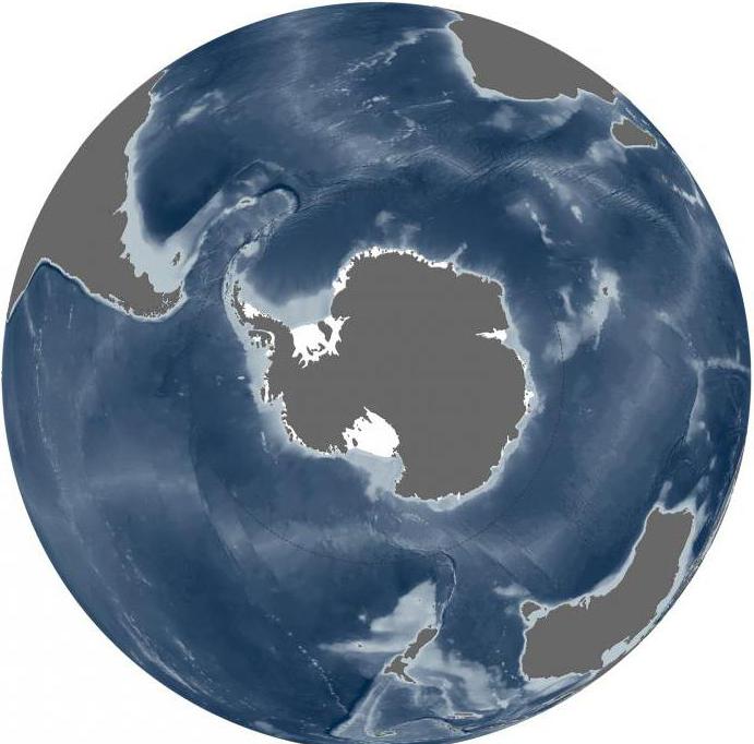
Antarctica is a continent, and the Arctic is geographical area, most of which is located at the North Pole.

Rice. 1. Arctic and Antarctica on the map.
The Arctic covers the extreme parts of North America and Eurasia. The territory of the Arctic includes the island of Greenland and many archipelagos that are located in the Arctic Ocean, for example, Severnaya Zemlya or Franz Josef Land.

Rice. 2. Franz Josef Land.
Translated from ancient Greek the word "Arctic" is translated as "bear". In Greek, it sounds like "arktos".
Antarctica is a continent with an area of 14.1 million sq. km. It is on this continent that the lowest temperature on earth is recorded - 89.2 degrees. The average temperature in summer is -35 degrees, and in winter - -65 degrees.
One of the main differences between Antarctica and the Arctic is that Antarctica is completely unsuitable for human habitation. This territory does not belong to any state. The population is from 1500 to 4000 people, but these are not permanent residents, but scientists and researchers who live on the mainland for no more than a year and a half. About 4 million people live in the Arctic, with 2.3 million people living in the Arctic part of Russia.
TOP 4 articleswho read along with this
Differences between Antarctica and Antarctica
The word "Antarctica" appeared only in the last century. It means "opposite to the Arctic". Indeed, the Arctic and Antarctic are located at different poles of the Earth - North and South.
What about Antarctica and Antarctica? Is it one and the same? So how are Antarctica and the Arctic different?
Antarctica, as mentioned above, is only the mainland. Antarctica, on the other hand, is a territory that, in addition to Antarctica, includes the waters of three oceans (Indian, Pacific, Atlantic), limited by the course of the westerly winds, as well as various islands that are located in the waters of these oceans. The center of Antarctica is the South Pole.
Antarctica is the heart of Antarctica. Because of the glaciers that cover the continent, it is the highest continent in existence. The average height of the glaciers is 2040 meters.

Rice. 3. Glaciers of Antarctica.
The cold pole of our planet is located just in Antarctica. At the Vostok polar station 35 years ago, in 1983, a record low temperature of 89.2 degrees was recorded.
What have we learned?
In this article, the difference between Antarctica and Antarctica was considered, and a comparison was made between the Arctic and Antarctica. The Arctic is adjacent to the North Pole and includes almost the entire North Arctic Ocean, as well as the extreme parts of Eurasia and North America. Antarctica is a continent that belongs to the Antarctic region. It was here that the lowest temperature on the planet was recorded.
Topic quiz
Report Evaluation
Average rating: 4.3. Total ratings received: 228.
Antarctica is an icy continent in the very south of the planet. The sixth continent was discovered by Russian navigators Thaddeus Bellingshausen and Mikhail Lazarev in 1820.
According to the international convention on Antarctica, this territory does not belong to any country in the world.
There is no permanent population here, but an active scientific activity. Seven out of 45 Antarctic stations belong to Russia. Antarctica has huge reserves of fresh water (about 80% of all fresh water on Earth), and there are also significant mineral reserves.
Map of Antarctica

Despite the huge natural wealth, the entire world community recognizes the inadmissibility of intrusion into the fragile world of Antarctic nature, now only the tourism business is actively developing here. About six thousand tourists visit these harsh places every year! You and I can try to understand what attracts tourists to this distant continent so much by online walk on this amazing land (see “Walk in Antarctica” and “Antarctica online“).
IN last years interesting studies of the relief of the mainland were carried out and new maps were compiled. The study of the topography under the Antarctic ice sheet is critical to understanding the dynamics of the ice sheet, its thickness, and the impact on the surrounding ocean and global climate.
satellite antarctica
Influencing ocean currents and sea level rise, this continent plays a huge role in the Earth's climate system. Using various methods, researchers are trying to predict how Antarctica will react to climate change.

Information about the thickness of the ice and the structure of the mainland was limited. Now, thanks to work done by the British Antarctic Survey (BAS), scientists have a new detailed map continent. The video will tell us how the work on compiling the map was carried out:
Commenting is closed.
Antarctica: description, photo, where it is on the map, how to get
Antarctica- the southernmost, and at the same time the coldest continent on Earth, washed by the waters of the Southern Ocean. Near the mainland there are a number of adjacent islands. Antarctica was the last continent discovered by scientists. Today, tours to this glacial continent are possible from South America and New Zealand. It is included in 1000 the best places world according to our site.
The total area of the continent exceeds 14 million km², and its ice cover is more than 80% of all fresh water our planet. The study of glaciers has become a special field of science called "glaciology". For centuries, scientists could not get to the interior of Antarctica, as it was blocked by ice shelves. So, in the 18th century, the English navigator J. Cook, setting off in search of the last continent, crossed the line of the Antarctic Circle, but never found it.
F. Bellingshausen and M. Lazarev are considered to be the discoverers of the mainland. It was these Russian travelers who in 1820 managed to swim up to the eternal glaciers of Antarctica. The Norwegian polar explorer R. Amundsen made his way deep into the mainland already in the 20th century. Continuous exploration on the continent began in the 1950s. Currently, for all inquisitive tourists, excursions are conducted on board the expedition liner.
Such excursions provide an opportunity to admire the majestic sheer ice floes, which in some places reach 180 meters in height. Some of these hulks are as big as entire states. Icebergs often form on their basis. One of the most unique features in the Southern Ocean is the Ross Ice Shelf. He has long been calling card Antarctica.
Its area is more than 470 thousand km².
This giant object was discovered by the English explorer J. Ross, after whom it got its name. Today, interested tourists have the opportunity to get to the glacier with transparent blue walls by helicopter flight. Eyewitnesses claim that the spectacle is fantastic.
Off the western shores of the mainland, there is another picturesque hulk - the Ronne-Filchner glacier. The easiest way to get to it is from the city of Ushuaia in Argentina. It is said that once every 15 years an iceberg breaks off from the glacier and for the sake of this spectacle it is worth visiting an Antarctic cruise. And, of course, many people want to visit the so-called "capital" of Antarctica - on the McMurdo Ice Shelf. It is home to over 100 buildings and a major research station.
Photo attraction: Antarctica


Antarctica on the map:
Antarctica is the main polar region of the planet, which includes the mainland Antarctica, as well as other islands and seas.
Axis has already been over 200 years of this Suvorian region to drive mandrivniks and dosledniks to oneself. James Cook, having risen in price with the polar seas in 1774, having built only heaps of sea criga on his way. Without watering the land, the great navigator categorically declared that there was no pivdenny mainland. Since then, perhaps, no one has tried to make jokes.
The last significant successes in the passage to Antarctica were reached by the expeditions of the Englishmen William Smith and Edward Brandswilde. The Russians Fadey Bellingshausen and Mikhailo Lazarev are respected as the pioneers of the mainland, as if by their expedition of 1820 they brought the foundation of the mainland to the rock, they marked out the boundary of the special climate.
The next seventy fates of the mainland rose from the sea - too soon to be suvorim and impregnable, they took care of it. Lesser in 1895 by the Norwegians L. Christensen and K. Borchgrevink mainland stage The legacy of Antarctica - many people visited the shores of the continent and chose the first collection of not rich Antarctic flora. In the XX century, expeditions to Antarctica become regular - Britain, Germany, Sweden, Norway, Australia, Japan send their expeditions there.
Under the root of the Pivdenny Pole, the baby was born in 1911. Norwegian Roald Amundsen, who outperformed his competitor English Robert Scott for a month.
Antarctica - the mainland at Pivdenniy pivkul, lie near the pivdenny geographic pole. The area with shelf ice floes and islands in the middle is 14,100 yew. km2.
Antarctica is surrounded by three oceans: Indian, Atlantic, and Pacific. Inland seas Antarctica, obviously, can not, because 99% of its territory is covered by ice floes.
The volume of ice is 24.9 million km3 - over 80% of the volume of fresh water on the planet.
Antarctica is the largest continent on the planet. The ice curve, which has settled here about 20 million years ago, in some places rises to a height of 4,800 m. indigenous that upper ice age.
The average height of the mainland is more than 2,000 m (the highest in the middle of other continents), while the part of the plain arid part of Antarctica has fallen under the tovshey ice and is lower than the sea level. The western part is cut off by ridges, one of which is crowned by the wild volcano Erebus. Transantarctic mountains stretch across the mainland. The best point of the mainland is located on the Vinson massif (5,140 m). The ice-buildings of Antarctica are steadily collapsing. On the edges of the mainland, the ice rises, appeasing icebergs.
In Antarctica, a rich brown copalin was found (kam'yan vugillya, ore deposits, chromium, nickel, gold). That z looking at the severity of the climate and the unsafe destruction of the ecologically equal to the unique region of the planet, the growth of genera was recognized as invisible and not social.
More interesting articles:

Incredible Facts
Probably, most people who have long graduated from school will not immediately be able to give an answer about the difference between the Arctic, Antarctica and Antarctica - where are they located, and how do they differ?
Many doubt the main account because of the similarity of names and almost identical climatic conditions.
We can only say with confidence that there is a lot of snow, ice and icebergs here and there.
What are the similarities between the Arctic, Antarctica and Antarctica
To better understand how they are similar and how they differ, it is worth starting with what these places have in common.

Name
To be more precise, this is not a similarity, but rather a contrast.
The word "Arctic" is of Greek origin. Arktos means bear. It is associated with the constellations Major and Ursa Minor that guide people in search of polar star, that is, the main northern landmark.
The word "Antarctica" was invented quite recently, or rather in the twentieth century. The history of its origin is not so interesting. The fact is that "Antarctica" is a combination of the two words "anti" and "Arctic", that is, the opposite part of the Arctic, or the bear.
Climate

Eternal snow and icebergs are the result of harsh climate conditions. This is the second similarity of the above territories.
However, it is worth noting that the similarity is not entirely complete, since the climate of the Arctic is still milder due to warm currents that go quite far along the northern coast of the Eurasian continent. Here, the minimum temperature exceeds the Antarctic minimum temperature.
What is the difference between the Arctic, Antarctica and Antarctica
Arctic

The northern polar region of our planet, which is adjacent to the North Pole.
The Arctic includes the outskirts of two continents - North America and Eurasia.
The Arctic includes almost the entire Arctic Ocean and many islands in it (except for the coastal islands of Norway).
The Arctic includes adjacent parts of two oceans - the Pacific and the Atlantic.
The average temperature in the Arctic is -34 C.
Arctic (photo)


Antarctic

This is the southern polar region of our planet. As already mentioned, its name can be translated as "the opposite of the Arctic."
Antarctica includes the continent of Antarctica and adjacent parts of the three oceans - the Pacific, Atlantic and Indian along with the islands.
Antarctica is the most severe climate zone on Earth. Both the mainland and nearby islands are covered with ice.
The average temperature in Antarctica is -49 C.
Antarctica on the map

Antarctica (photo)


Antarctica
A continent located in the southernmost part of the globe.

Antarctica on the map

Simply put:
Antarctica and Antarctica

1. Antarctica is the mainland. The area of this continent is 14.1 million square meters. km., which puts it in 5th place in terms of area among all continents. He overtook only Australia in this parameter. Antarctica is a deserted continent discovered by the Lazarev-Bellingshausen expedition in 1820.
2. Antarctica is a territory that includes both the mainland Antarctica itself, and all the islands adjacent to this mainland and the waters of the three oceans - the Pacific, Atlantic and Indian. According to foreign scientists who call the Antarctic waters the Southern Ocean, the area of Antarctica is about 86 million square kilometers. km.
3. Relief Antarctica is much more diverse than the topography of the mainland that it includes.


