There are settlements that are prosperous, dying, and there are dead ones. The latter always attract a large number of tourists and adventurers. main topic of this article - the abandoned villages of the Moscow region. It is very difficult to say how many of them there are in the Moscow region, and indeed in Russia in general. After all, every year there are new abandoned villages. You can also see photos of these villages in this article.
- the problem of Russia
No wonder they say that it is the soul of the country and the people. And if the village dies, then the whole country dies. It is very difficult to disagree with this statement. After all, the village is indeed the cradle of Russian culture and traditions, the Russian spirit and Russian poetry.
Unfortunately, abandoned ones are not uncommon today. Modern Russians increasingly prefer the urban lifestyle, breaking away from their roots. Meanwhile, the village is degrading and more and more abandoned villages appear on the map of Russia, the photos of which amaze with their despondency and longing.
But, on the other hand, such objects attract a large number of tourists and the so-called stalkers - people who are eager to visit various kinds of abandoned places. Thus, the abandoned villages of Russia can become a good resource for the development of extreme tourism.
However, the state should not forget about the problems of the Russian village, which can be solved only by a complex of various measures - economic, social and propaganda.
Abandoned villages in Russia - the reasons for the degradation of villages
The word "village" comes from "tear" - that is, to cultivate the land. It is very difficult to imagine authentic Russia without villages - a symbol of the Russian spirit. However, the realities of our time are such that the village is dying, a huge number of once flourishing villages simply cease to exist. What's the matter? What are the reasons for these sad processes?
Perhaps the main reason is urbanization - the process of rapidly increasing the role of the city in society. Big cities attract everything large quantity people, especially young people. Young people leave for cities to get an education and, as a rule, do not return to their native village. Over time, only the elderly remain in the villages, who live out their lives there, as a result of which the villages die out. For this reason, almost all the abandoned villages of the Moscow region appeared.

Another fairly common reason for the degradation of villages is the lack of jobs. Many villages in Russia suffer from this problem, as a result of which their inhabitants are also forced to go to the cities in search of work. Villages can disappear for other reasons as well. For example, it can be a man-made disaster. Villages can also degrade as a result of changes in their economic and geographical position. For example, if the direction of the road changes, thanks to which a particular village has been developing all this time.
Moscow region - the land of ancient temples and estates

Podmoskovye is an unofficial name. The historical predecessor of this region can be considered the Moscow province, which was formed back in 1708.
The Moscow region is one of the leading regions in terms of the number of objects cultural heritage Russia. This is a real paradise for a tourist and a traveler: more than a thousand ancient temples and monasteries, dozens of beautiful estates, as well as numerous places with long-term traditions of folk art crafts. It is in the Moscow region that such ancient and interesting cities as Zvenigorod, Istra, Sergiev Posad, Dmitrov, Zaraysk and others are located.

At the same time, the abandoned villages of the Moscow region are also well known to many. There are a lot of them in this region. About the most interesting abandoned villages of the Moscow region will be discussed Further.
Such objects attract primarily extreme people, as well as local historians and various lovers of antiquity. there are many such places. First of all, it is worth mentioning the Fedorovka farm, the villages of Botovo, Grebnevo and Shatour. These abandoned villages near Moscow on the map:

Khutor Fedorovka
This farm is located 100 kilometers from Moscow. In fact, this is a former military town, so you will not find it on any of the maps. Around the beginning of the 90s, the village of 30 residential buildings completely fell into disrepair. At one time, it had its own boiler house, substation, and also a shop.
Botovo village
The old village of Botovo is located in the Moscow region, near the Volokolamsk station (Riga direction). Once in this area was the estate of Princess A. M. Dolgorukova. The center of this estate was a wooden church, which was built in the 16th century (the church has not been preserved). The last owner of the estate in Botovo, as you know, gave it to the peasants at the beginning of the 20th century.
Of the surviving objects in Botovo, you can only see the ruins of the Resurrection Church, built in the 1770s in the pseudo-Russian style, as well as the remains of an old twenty-hectare park. There are still old birch and linden alleys in this park.
Village Grebnevo
Grebnevo is a 16th-century estate with rich interesting history and pretty tragic fate. It is located forty kilometers from the capital, on the Shchelkovo highway.
The first owner of the estate was B. Ya. Belsky, the gunsmith of Tsar Ivan the Terrible, then the Vorontsovs and Trubetskoys owned the estate. In 1781, Gavril Ilyich Bibikov became the owner, it was under him that the estate acquired the form in which it has survived to this day.
Dramatic pages in the history of the estate in Grebnevo are connected with the beginning of the Soviet era. The nationalization of the complex led to the fact that the buildings gradually began to lose their historical appearance. First of all, all the internal interiors of buildings were affected. At first, a tuberculosis sanatorium was located within the walls of the estate complex, then a technical school. And only in 1960 the Grebnevo estate was declared an architectural monument of republican significance.
In the late 1980s, the estate seemed to have received a new impetus for its development and preservation. A cultural center was formed here, and various concerts, events and exhibitions began to be held regularly on the estate. Active restoration work began to restore the complex. But in 1991 there was a huge fire, after which only the frames of manor buildings and structures remained from it. In this state, the Grebnevo estate remains to this day, more and more turning into ordinary ruins.
Shatour village
The old village of Shatour has been known since the 17th century. It is located on poor soils, so the main occupation of the locals has always been hunting. Perhaps it was for this reason that the village fell into decay in the middle of the 20th century.
Today the village is completely deserted. Occasionally, the owners of individual houses visit here (several times a year). Among the abandoned village, the old brick bell tower looks great, towering over the deserted village.
Reminder for the extreme tourist
Despite their gloom and decrepitude, old uninhabited villages and other abandoned places are of great interest to many tourists. However, travel to such objects can be associated with certain dangers.

What should the so-called extreme tourists know?
- firstly, before going on such a trip, you should notify your relatives or friends about your trip, its timing and the route of your movement;
- secondly, you need to dress appropriately; remember that you are not going for an evening walk in the park: clothes should be closed, and shoes should be reliable, durable and comfortable;
- thirdly, take with you the necessary supply of water and food, also in your backpack should be a flashlight, matches and a standard first aid kit.
Finally...

The old villages of the Moscow region amaze travelers with their desolation and picturesqueness. I can't even believe that such objects can be located just a few tens of kilometers from the capital - the largest metropolis on the planet! Getting into one of these villages is like using a time machine. It seems like time has stopped here...
Alas, the number of abandoned is growing every year. Perhaps someday this problem can be solved. But for now, abandoned villages serve only as objects of interest for all kinds of extreme people, stalkers and lovers of gloomy antiquity.
Topographic map of the Moscow province, engraved at the Military Topographic Depot in 1860 on 40 sheets. The scale is 2 versts in the English inch 1:84000.
Of considerable interest is not only the process of creating the map itself, but also the historical period of time that preceded its appearance.
IN late XVIII century, a radical transformation of the cartographic business in Russia took place, which marked the beginning of an independent military topographic service. Emperor Paul I, shortly after coming to the throne, paid special attention to the lack of good cards and on November 13, 1796, he issued a decree on the transfer of all maps of the General Staff to the disposal of General G.G. Kushelev and on the foundation of His Imperial Majesty the Drawing Room, from which in August 1797 His Majesty's Own Map Depot was created.
This act made it possible to bring order to the publication of maps and made the Map Depot centralized state archive cartographic products in order to preserve the state and military secrets. At the Depot, a specialized engraving department was established, and in 1800 the Geographical Department was added to it. On February 28, 1812, the Depot of Maps was renamed the Military Topographic Depot with subordination to the War Ministry. Since 1816, the Military Topographic Depot was transferred to the jurisdiction of the General Staff of His Imperial Majesty. In terms of its tasks and organization, the Military Topographic Depot was primarily a cartographic institution. There was no department of topographic surveys, and the necessary number of officers from the army was seconded for the production of maps.
After the end of the war with Napoleon I, much more attention began to be paid to field topographic and geodetic work. Military operations revealed a shortage in maps, and new methods of warfare at that time raised the question of the need for large-scale maps, which, in turn, required a good and fairly dense network of reference geodetic points and accurate topographic surveys. Since 1816, the triangulation of the Vilna province began, which laid the foundation for the development of triangulations in the country, and since 1819, regular topographic surveys were organized on a strict scientific basis. However, the performance of geodetic and topographic work by a small number of officers of the quartermaster unit, who, in addition to this, had a lot of other official duties, did not allow starting the process of planned and systematic mapping of the country.
In addition, the costs of maintaining topographic officers seemed too high. Therefore, the question arose of creating a specialized organization for surveying and geodetic work, staffed from persons of non-noble origin. Such an organization, which existed along with the Military Topographic Depot, was formed in 1822 and became known as the Corps of Military Topographers. Its composition was completed from the most capable pupils of the military orphanage departments - cantonists, sons of soldiers who belonged from birth to the military department in then serf Russia. In order to train the personnel of the Corps of Military Topographers, the Military Topographic School was founded in the same year. The corps of military topographers, established at the General Staff of His Imperial Majesty, became a special organization for carrying out geodetic work, topographic surveys and training a large number of highly qualified topographers.
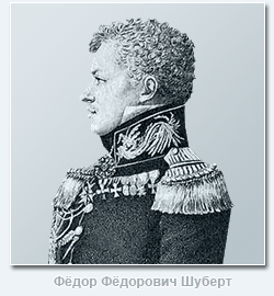 The activities of the famous Russian surveyor and cartographer F.F. Schubert, its founder and first director. Fyodor Fedorovich Schubert (1789-1865) was the eldest of the children and the only son of the outstanding astronomer Academician Fyodor Ivanovich Schubert (1758-1825). Until the age of eleven, he was brought up at home, with special attention paid to mathematics and comprehension of languages. During this period, F.F. Schubert read a lot of books from the home library, as well as from the library of the Academy of Sciences, which was in charge of his father. In 1800 F.F. Schubert was assigned to the Peter and Paul School, later renamed the school, without graduating from which, in June 1803, at the age of only 14, at the request of his father, he was transferred to the General Staff as a column leader.
Quartermaster General P.K. Sukhtelen, a close acquaintance of Fyodor Fyodorovich's father, instilled in the young man who dreamed of maritime service, great love for topographic and geodesic business. In 1804 F.F. Schubert was sent on two astronomical missions, for the successful execution of the first of them he was promoted to second lieutenant. In the spring of 1805, he took part in a scientific expedition to Siberia led by his father, and in the summer of 1806 he was again busy with astronomical work in Narva and Revel. From October 1806 to February 1819 F.F. Schubert was in the army, taking part in hostilities against the French, Swedes and Turks. During the battle of Preussisch-Eylau in 1807, he was seriously wounded in the chest and left hand and almost died during the attack of Ruschuk. In 1819 F.F. Schubert was appointed head of the 3rd department of the Military Topographic Depot of the General Staff, and from 1820 he became the head of triangulation and topographic survey of the St. Petersburg province and in the same year received the rank of major general.
In 1822 F.F. Schubert develops a draft regulation on the Corps of Military Topographers and soon becomes the first director of the newly established Corps. After 3 years, he was appointed manager, and from 1832 - director (until 1843) of the Military Topographic Depot of the General Staff and the Council of the General Staff Academy. In addition to the positions of F.F. Schubert from 1827 to 1837 was also the head of the Hydrographic Depot of the Main Naval Staff of His Imperial Majesty. Fedor Fedorovich successfully combined the management of these institutions with a number of other equally responsible duties. He supervises extensive trigonometric and topographic work in a number of provinces, organizes the publication of "Notes of the Military Topographic Depot" and "Notes of the Hydrographic Depot"; composes and publishes the "Guide for the Calculation of Trigonometric Surveys and the Works of the Military Topographic Depot", which served as the main guide for topographers for several decades. June 20, 1827 F.F. Schubert was elected an honorary member of the St. Petersburg Academy of Sciences, and in 1831 he was promoted to lieutenant general for his distinction in service.
The cartographic works of Fyodor Fedorovich are of considerable importance, especially the ten-verst special map of the Western part of Russia that he published on 60 sheets, known as the "Schubert Maps", as well as his works devoted to the study of the type and size of the Earth. In 1845 F.F. Schubert becomes general of infantry, and the following year he is appointed director of the Military Scientific Committee of the General Staff, which he led until its abolition in 1859. With such an abundance of responsible positions, F.F. Schubert not only did an excellent job with the duties assigned to him, but also brought a lot of new things to the business of each institution in which he had a chance to work, so his contribution to the development of the domestic military topographic service was very important, and his authority in the scientific world is very huge.
free from public service Fedor Fedorovich devoted time to numismatics (in 1857 he published a detailed work on this issue). He was fluent in four languages, perfectly versed in music and painting, was a multifaceted, hardworking and cultured person.
The name of General Schubert is also associated with the creation of a topographic map of the Moscow province, which was engraved at the Military Topographic Depot in 1860. As already indicated above, since 1816, large-scale work began in Russia on laying triangulation and producing topographic surveys based on a strict scientific basis. In 1820, he began his extensive triangulation work and F.F. Schubert. In the period from 1833 to 1839, under his leadership, the triangulation of the Moscow province was carried out, which was fully completed only by 1841. A big drawback of the triangulation work of F.F. Schubert was that he did not pursue the goal of obtaining such a high accuracy, which was inherent in the triangulation of K.I. Tenner and V.Ya. Struve, who at that time were in charge of similar work in Russia. F.F. Schubert attached a purely utilitarian meaning to these works - to provide support only for current topographic surveys, since, being the director of the Military Topographic Depot, he tried to get maps of the largest possible territory of the country. In addition, in his triangulations, F.F. Schubert did not pay due attention to finding the heights of points, which was keenly felt when bringing the lengths of the measured bases to the sea surface. However, these shortcomings of the triangulation work of General Schubert were more than made up for. high quality instrumental topographic surveys carried out under his supervision.
The rules for filming have been subject to all sorts of variations over time. General provisions, true for most cases, were as follows. Trigonometric points were intended as the basis for the breakdown of the geometric network. Only the main objects of the area were filmed instrumentally: big roads, rivers, borders of provinces. For this purpose, the serif method was widely used; in forest spaces it was allowed to use a compass. The main content of the map was depicted with the help of an eye. In the course of the survey, the relief was rendered by contour lines indicating the angular magnitude of the slopes of the terrain, and only the contours of the peaks and thalwegs were instrumentally plotted. The relief was drawn in a chamber setting with strokes in the Leman system.
Topographic instrumental surveys in the Moscow province under the direction of F.F. Schubert were produced in 1838-1839. At this time, only space in the districts of Moscow was filmed. Filming was done on a scale of 200 fathoms to an inch. The requirements that Fedor Fedorovich made to the performers of field work were very high. Suffice it to say that F.F. Schubert strictly forbade the use of a compass, as it could not give the accuracy that could be achieved by filming forest roads using alidade. Subsequently, based on the materials of these surveys, in 1848 a topographic map of the environs of Moscow was issued on 6 sheets on a scale of 1 verst per inch. After quite a long time, the shooting of the Moscow province was continued. In the years 1852-1853 they were produced under the direction of Major Generals Vietinghoff and Rennenkampf and were conducted on a scale of 500 fathoms per inch.
Topographic surveys in the Moscow province were carried out by the Corps of military topographers, but we can hardly now accurately identify the direct executors of field work, since their names are not on the map of 1860. But on each of the 40 sheets, we can read the names of the engravers of the Military Topographic Depot below, who prepared this map for publication. In the fragment of this map, presented to your attention, there are four incomplete sheets on each of which 6-7 people worked. Interestingly, among the latter were two free engravers invited from abroad: Yegor Eglov and Heinrich Bornmiller. These artists taught our engravers the best European methods of engraving and took a direct part in the work "for which, in 1864, the Sovereign Emperor Deigned to welcome them silver medals to be worn on the ribbon of the Order of St. Stanislaus, with the inscription "for diligence"".
The original topographic map of the Moscow province of 1860 is a print from an engraving on copper on 40 sheets + a prefabricated sheet, executed in one color. The borders of the province and districts are manually raised with red watercolor paint. The map was compiled in a trapezoidal pseudo-cylindrical multifaceted Muefling projection on a scale of 1:84,000 or, translated into the Russian system of measures, 2 versts per inch. When compiling the map, materials from topographic surveys made in 1852-1853 were used, but it should be noted that the surveys of 1838-1839 were also the basis for creating this map for those sheets that cover the territory of Moscow and its environs. The content of the map is perfect. Of particular interest is high skill engravers, thanks to which all elements of the map are perfectly readable. The relief is beautifully engraved, especially the ravine network: the smallest spurs are drawn, which on the current topographic maps of a similar scale can simply be missed. A considerable number of different objects are signed on the map, which makes it possible to use it as the most valuable source of data on toponymy, since many hydronyms are partly lost today - they cannot be found on any large-scale topographic map. Even in our time, almost 140 years later, with the help of this document, one can quite confidently navigate the countryside. It is not surprising that in Soviet time The presented card was in the category of secret.
Even last winter, I became interested in studying fairs until 1917 on the territory of the Moscow province. I read quite a few articles and books from which I emphasized quite a few information for general development. It's fun to read history. I recommend.
Naturally, at first he used the list of fairs in 1787 and 1834, as well as the lists of the "Populated area of the Moscow province." All this is available on the Internet in the public domain and anyone can familiarize themselves with it. Another thing is when you start looking for these villages and cities on modern maps, or even graveyards. The names of settlements have changed, and moreover, in the past, the owner of a particular place called it by its own name, and he owned, for example, ten villages. A couple of villages with the same name could even be in the same county. So, sorting through and sorting through the lists, old and modern maps, I drew a modern map with notes where and what fairs were. If there was information, he made notes on the volume of trades, the number of people, the time of the event and how many days the fair took place.
I understood the reasons for such popularity of the famous Rogachev Fair. Many have heard about the Field of Miracles in Rogachevo. These are three fields located on the outskirts of the village.
There seems to be nothing complicated. People traded and traded and everyone knows about it. But why was there such an active trade in this place and for quite a long time - several hundred years?
Let's consider a map.

And let's look at the same place through the eyes of Schubert.

Quite convenient and safe way on the water from the Volga. As you know, the condition of the roads in those distant times was .... Yes, there were no roads in those distant times. There was a single number of tracts, and the rest were ordinary dirt roads. Only the paths were covered with stone. Someday I will tell about my walks along two such paths. It is quite interesting to see a stone-paved road when there is no hint of civilized roads in the area. But that's in the future. Due to the lack of roads, moving on carts was quite difficult and time consuming. If we take the speed of a loaded cart 5-7 km / h, then it is not difficult to calculate that in 10 hours you can drive 50-70 km. But this can only be considered in problem books in arithmetic. The maximum duration of a horse's working day is 10-12 hours. The horse is fed 3-4 times a day. The horse can start working 30 minutes after feeding. In order to feed the horse, it is enough to hang a sack on the horse's muzzle, but in order to give it a drink, it is necessary to unharness it. And it turns out that the cart moves at a speed of 5-7 km / h, not for 10-12 hours, but at best for eight hours. From this we conclude that the maximum distance that a horse and cart can travel in a day is 40-50 kilometers.
Horses pulled the same barge along the Yakhroma River, but the transported cargo per horse varied significantly. The legend of the name of the river Yakhroma is very interesting. Allegedly, Yuri Dolgoruky was accompanied by his wife on a trip to the principality. To rest near the river, the princess dismounted and stumbled while exclaiming - "Oh! I'm lame." Surrounding people took it as the name of the river. Since then, it has become customary to call this river Yakhroma.
Those wishing to take a walk along the Yakhroma coast in the Rogachevo region should take into account that the channel in this place was greatly changed due to reclamation work. The new channel is clearly visible on modern maps, and we can see the old one on Schubert's maps.
The village of Rogachevo is the central transit point of the trade route from Moscow to the north, and the fair here was precisely on a national scale. It could not be closed only by those three fields that I marked in the first picture. Trade was conducted from Ust-Pristan to the Nikolo-Peshnoshsky Monastery (Lugovoy). Barges stood near the shore and merchants sold their goods directly from them. If you walk along the shore, you can see the recesses, as if intended for the parking of such ships. We conclude that trade was carried out almost along the entire course of the Yakhroma River from Ust-Pristan to the Nikolo-Peshnoshsky Monastery and, naturally, in those places where there was a convenient access (see Schubert's map). Trade was also carried out on the sections between Aleksandrovo-Kopylovo and the river. On the Sestra River, the ships went up to Trekhsvyatskoe. There, the main place of trade was near Cherneev. Well, then the loaded carts went to Klin, some to Dmitrov, or some to Moscow. In Klin, the fairs were weekly on Saturdays, and in Dmitrov, in addition to the weekly fairs, there was another weekly one on September 15th.
Further along the circle is the famous Teryaevo and the Joseph-Volotsky Monastery. Fairs were held there on 15 August and 8 September. Up to 3,500 people gathered fairs there. The goods were brought for 20,000 rubles. And nearby, five kilometers away, a small fair in Spirovo was held on November 21st. People from the surrounding villages came and traded in every little thing.
I will note one more place that is not remarkable today, where there used to be a monastery and a churchyard. This is Nosovo. There is no such place now. This is near the village of Yastrebki, Odintsovo district. Assumption Safroniyev Monastery is mentioned as early as the 15th century. Here, near it, there were auctions for the surrounding villages. Up to 1,500 people gathered at the auction and the turnover was 3,500 rubles.
Somewhere there was a monastery.

And it looks like the fair itself was held here.

When the dam appeared, I could not find out.

Forest next to the trading place. Perhaps merchants and buyers rested in it, or maybe they marked transactions.

There were several large fairs in the south of the Moscow province. One fair in Dedinovo that meant. The Oka River made it possible for merchants to come to the fair from many cities. The malls were on the banks of the river. There were two rows. In one, food supplies were sold, and in the other, on Fridays, all kinds of goods from the surrounding villages. When the railway was built, the goods were delivered from the Lukhovitsy station and mostly it was cattle. I can assume that the cattle was not transported to the left bank of the Oka. Trades most likely on July 8 and September 8 were held on both banks. Further along the left bank of the Oka is Beloomut, which previously consisted of the Lower and Upper. Three fairs were held in Nizhny Beloomut. On Monday, Shrovetide auctions lasted two days, three days on Ascension, and one day on October 1, with a two-day delay. They traded cattle, manufactory and haberdashery goods, as well as hay and fish and everything else that was possible. There were weekly bazaars in Upper Beloomut on Mondays. Pervitsky Torzhok due to its proximity railway and the river weekly on Saturday received trading people from many cities and villages.
And now I want to tell you about the fair that attracted me more than all of the above. There is still a story about one unknown fair ahead, but in terms of trading volume it is comparable to Rogachevskaya, but I will try to tell about it later and in a separate topic on November 15.
The fair was held in the village where the Church of the Icon of the Mother of God of Kazan was built in 1752. There were 46 households in the village in which 171 males and 163 females lived. Literacy was taught in the local school. Due to a fire in 1870, the church was rebuilt.
On July 8, goods were brought from Kashira, Tula, Serpukhov, Venev and Zaraysk. These auctions were held on the square in the center of the village.

The thing is that there are two villages with the name Bogatishchevo. The second Bogatishchevo-Epishino is 14 km to the north and more attention is paid to it. All search engines, when typing Bogatishchevo, point to the railway station, which is in no way associated with the village where the fair could be held. As you can see from the picture, the village itself is located a little south of the railway station. In Soviet times, a poultry farm was built to the north of the village, and a treatment plant for this poultry farm was built to the east. The poultry farm and treatment facilities are now not operating and you can take a walk in the fresh air in the vicinity of the village with great pleasure. You can walk to the Bolshoe Lyubilovo tract and swim in the reservoir, but this is of course on a warm summer day. Now it may be better to direct your feet towards the Svinoe tract. Previously, there was a temple complex. The village itself ceased to exist, but dachas began to grow around that place. The walk should be enjoyable. See map.

At the same time, to your attention from the Schubert map.

And at the same time and PGM.

View of the sewage plant across the field

And this is the Church of Our Lady of Kazan in the neighboring village of Rastovtsy. The history of the village is interesting, but there was no fair there and we will talk about it some other time.

If someone will be in these places and take photos, I will be ready to accept them as a gift and post them on the blog. Happy travels.
In the 15th century, a man came from Greece. You can imagine from Greece on foot to our edges. A man lived in orange groves, ate olives in unlimited quantities. Then once and having collected the katomku and went to the north. He found a lake and formed a settlement on the island. And this happened around the year 1431. They did not grieve until there was not enough space for them. And then they turned to the king with a bow. The good Tsar Ivan the Terrible (he has such a surname), being in a good mood, signed a letter in which he donated the surrounding land for the construction of the Nikolo-Radovitsky Monastery. It happened in 1584. And in order to have a stable income at the monastery, they began to hold annual fairs there on the 9th and 10th weeks of Easter. There were plenty of places, so the people walked for two weeks. And all this happened in the village of Radovitsy, Yegoryevsky district. The places are deaf, overgrown not only with grass and shrubs, but also with tree growth.
A little to the north there is a place that was mentioned in the cadastral books of 1587. The beautiful old Church of the Intercession of the Most Holy Theotokos was built in 1801. Fairs were held in front of the church. Access to the field on an asphalt road.
Let's go north. We will find the small village of Tugoles. The magnificent Church of the Great Martyr Paraskeva (Friday) opens unexpectedly. Beautiful domes in the forest. A bewitching spectacle. This must be seen. If you saw domes in the forest, then you turned left and soon you will run into the end of the road, and then there is already a rolled primer and you can’t drive through in wet weather. And yes, there is nowhere to go. To the left will stretch a huge field overgrown with grass suitable for haymaking. To the right is an abandoned regional hospital. The number of gadflies living in that region simply cannot be counted. You can say the edge of the vodka. They can be caught there and exported abroad in huge quantities.

However, dear readers of the blog are waiting for the continuation of the story about the fairs of the Moscow province. I will describe to you the fair that took place in the village on the Venevskaya postal road. Traded there on the feast of the Trinity. Traded from the cities of Zaraysk, Tula, Serpukhov, Kashira and other others and others. The entrance was convenient. There was a village on the road. Now you have to walk to get there. The locals prefer a tractor. I didn't see any other traffic. The car can be left in a neighboring village near the church and on foot three kilometers with a tail.

The map clearly shows the location of the village of Gritchino in those days of the Kashirsky district. I think you can easily find it on modern ones, just don't confuse it with the village of Gritchino, Kashirsky district. By the way, the village has already been renamed into a village, and therefore it is necessary to choose which village of Gritchino to go to. The place for a walk is interesting, just do not bypass the gardens. Follow the path through the gardens. Enter the village and you will immediately see the remains of the church on the left, and there you can choose any direction for further travel. If you head to Khrenovo, then after 2.5 km you will run into the remains of a village near the river, and after another couple of kilometers, Khrenovo itself. I almost forgot to the left across the river the churchyard was about two churches. Oh! Forgot. We're talking about fairs. The fair was in Gritchino.
Let's move to the Shakhovsky district, the village of Cherlenkovo. Let's take a look at this area.

The fair in Cherlenkovo was held on May 9 on Nikolin's day. In 1900, rumors spread that the earth from the grave of a charitable man named Philip helped from everything. At first, they took pinches of earth from the grave and simply carried it with them. The rumor about spread, and people crawled to the grave, and each person already took not a pinch, but a little piece of land. People began to come from neighboring provinces. I took a calculator and roughly calculated how much land people can carry away by taking just a reaper. Let's take a density of 2,000 kg/cu.m. A man in the zhmenu can take about 50 grams. One thousand people will take out 50,000 grams or 50 kg of earth on a zhmenka. Several thousand people passed there every day. I decided to take a walk to the place where there should be a foundation pit instead of a grave. Or maybe he would have taken a piece of land for good luck. And who knows, maybe he will bring good luck. Planned a route.

I looked at the satellite imagery and it looks great.

Printed out the map.

Tried to accommodate several thousand people in this territory. I could not imagine where they were located, what, and most importantly, where they ate. Where did they sleep? From articles about this event, we read that several thousand prosvir were sold per day. One prosvir cost 1 kopeck. The county candle warehouse did not have time to deliver candles to the church. The map shows where the church is located and where the cemetery is. And this small settlement in the spring of 1900 received thousands of people every day, fed them and put them to bed. According to the evidence, they baked bread in carts and sold it twice and three times more expensive. The locals certainly got rich. Every scam has its end. The police put things in order. No matter how I searched, I did not find the pit at the site of the grave of the charitable Philip. Walked from the north of the cemetery, then went down to the church and walked along the river bank. The places are beautiful and interesting.
About the nearest fairs in the district, these are Murikovo, Khovan, Levkievo and Sereda, it is written in the Reference book of the Moscow province of 1890.

"Fairs" on Yandex.Maps
To be continued.
Stay tuned.
(function(w, d, n, s, t) ( w[n] = w[n] || ; w[n].push(function() ( Ya.Context.AdvManager.render(( blockId: "R-A -261686-3", renderTo: "yandex_rtb_R-A-261686-3", async: true )); )); t = d.getElementsByTagName("script"); s = d.createElement("script"); s .type = "text/javascript"; s.src = "//an.yandex.ru/system/context.js"; s.async = true; t.parentNode.insertBefore(s, t); ))(this , this.document, "yandexContextAsyncCallbacks");
On the pages of this blog, I wrote quite a lot about the benefits of cards in our difficult, but interesting case- treasure hunting. Thanks to the maps, we learn about the old villages, where they were located, how the street went, and when it approximately existed and disappeared.
According to the maps, we can even find those places where the digger's foot has not set foot. So, in the spring of last year, we got into an unbeaten repair. On PGM there was only a barely noticeable small square. But in fact, there actually turned out to be a settlement where the four of us dug up quite well.
Thanks to maps, we can make our discoveries. Indeed, without them it is not known where to go, unless of course you talk with the local population or identify tracts by poplars, which can be seen from afar.
In our heyday of the Internet, almost any map, old or not, is easy to find and start working with. In this article I will talk about some useful maps in detecting, in particular, those that I use myself.
satellite imagery
I'll start with the newest cards. Satellite images are now of fairly good quality. From them we can see state of the art the place we are interested in. Whether the field is overgrown with forest, whether houses are left in the village, find out the way to the detecting point. This is very detailed map, but it is difficult to overlook the change in heights on it. The relief looks flat. The scale of the pictures is detailed. By the way, if there is no detailed clear picture of the desired area from one service, you can find one from another. For example, if Google's terrain is blurry, then Yandex's is likely to be of excellent quality.
General Staff Cards
Also quite interesting maps. They are intended for the military, which is clear from the name. But they were also popular with topographers, surveyors, geologists, road builders, and others who work on the ground. All maps of the General Staff are similar: sheets of individual squares, divided into smaller squares. The scale is different. From 250 meters to 10 km in 1 cm. A couple of times I heard that there are also hundred meters, that is, 100 meters in 1 cm. At the same time, the maps of the General Staff have a very low error and can be used with great success on a GPS navigator for orientation and navigation, as well as finding places to dig and plot routes. All villages are clearly indicated and it is written how many inhabitants there were at the time the maps were created, the order of the location of streets, roads, mills is shown. I often use it myself, besides, the General Staff is loaded into the ozik on the phone.

Maps of the red army
Maps of the Workers 'and Peasants' Red Army. They are very similar to the General Staff, but they began to be created back in the 20s of the last century. Due to the lack of funds, people and opportunities, pre-revolutionary maps were taken as a basis. These cards have limited coverage. Namely, you can find maps of the Red Army only in the western part of our country. Not even Kirov region. Although, somewhere there was a mention that there are topographic maps older than the General Staff of our regions. By the way, the inscription "Coordinate system of 1942" is often confused with the date of creation of this map. In fact, this is not the case, here we are only informed about the coordinate system. And the date of shooting and issue of the card is written in the upper right corner of the sheet. If the list of the General Staff was from 1942, then this is already a map of the Red Army. They, according to the information I have, were produced from 1925 to 1941. The scale is from 250 m to 5 km in 1 cm. Having examined this map, it attracted me with its detail and relative antiquity. It shows even the smallest settlements. The number of yards is indicated. Undoubtedly, a great map for a search engine! But it is a pity that it is not in our Vyatka region.

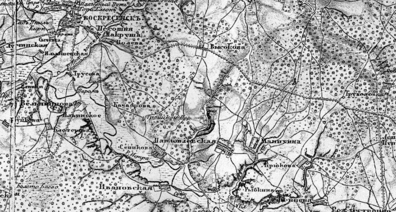
Schubert Map
With your permission, a brief background. At the beginning of the 19th century, F.F. Schubert headed the corps of military topographers and under him a 10-verst map was created Western parts Russian Empire on 60 sheets. But for some reason, it turned out to be inconvenient for practical use. I had to start working on a new one. It began to be created under the guidance of P. A. Tuchkov, but later Schubert took over the work on it. It covers the time period of almost the entire second half of the 19th century, starting from 1846. But the main work was done before 1863, when 435 sheets were made. Further work continued at a similar pace. In 1886, 508 sheets were drawn. Basically, they used the already compiled ten-verst line, only supplementing and clarifying it. Very good detail of objects. Literally everything that is needed is indicated: settlements, forests, rivers, roads, crossings, etc. There is even a character of the relief. Its scale is 3 versts in 1 inch or 1260 m in 1 cm. However, not all areas are drawn by Schubert. For example, Vyatka, alas, is not there.
(function(w, d, n, s, t) ( w[n] = w[n] || ; w[n].push(function() ( Ya.Context.AdvManager.render(( blockId: "R-A -261686-2", renderTo: "yandex_rtb_R-A-261686-2", async: true )); )); t = d.getElementsByTagName("script"); s = d.createElement("script"); s .type = "text/javascript"; s.src = "//an.yandex.ru/system/context.js"; s.async = true; t.parentNode.insertBefore(s, t); ))(this , this.document, "yandexContextAsyncCallbacks");
Strelbitsky Map
In the middle of the 19th century, I. A. Strelbitsky was a member of the Military Topographic Department under general staff and he was instructed to update and supplement the Special Map of the European part of Russia. Strelbitsky supervised this work from 1865 to 1871. The new map consisted of 178 sheets and covered the European part of the country and parts of the adjacent western and southern provinces. The scale is very inaccurate. There are 10 versts in 1 inch. And if translated in our manner, then 4200 m in 1 cm. In particular, this map was also used as the basis for creating maps of the Red Army. What to say about the map of Strelbitsky: a large error, only major roads and settlements are marked. Suitable, of course, as an overview map, but I do not use it.

Mende Map
Its author is A. I. Mende. From 1849 to 1866, he supervised the work on creating a map in the central provinces of the Russian Empire. When creating this map, 40 surveyors and 8 officers of the Corps of Military Topographers worked. Its scale is 420 m in 1 cm. A very interesting map, but it does not cover the entire European part of Russia. It's a pity ... This is a boundary map with decent detail. Very similar to PGM.

PGM or General Survey Plan
The oldest of the maps presented here and, despite its age, is very accurate and detailed. The decree to create a general survey plan was given in 1796. Under Catherine the Great, mass land surveying began: the country's territory was divided into counties, and they were divided into dachas - plots of owners who had rights to these lands within certain boundaries. They were assigned numbers, and their decoding is given in the economic note, which was an addition to the plan for each province. The scale of the map is 1 or 2 versts in an inch, which is the usual 420 meters in 1 cm. When superimposed on a modern map and when tied to satellites, you will encounter difficulty - an error and quite large. After all, this is not a map tied to coordinates, but just a plan. But enough detailed plan! You can get a lot out of it. useful information for searches with a metal detector about the time of occurrence of the point, its size at that time, the location of the street and houses, about roads and highways. Churches and church lands are marked, on which markets and fairs could be located, since these territories were not taxed. The map is very interesting and I use it. It is suitable as an overview map: look, think and go. I don't see the point in linking it. But it’s still worth putting on modern satellite images! By the way, some sheets, due to their dilapidation, may not be well preserved and instead of places of interest you will see a hole.

Thus, we have just examined those cards that are mainly used by treasure hunters. There are also other cards, but about them sometime later.
Each map is good in its own way and brings certain benefits to the digger when planning places for digging and studying the history of his area. And you need to use the cards at the same time, mentally overlaying them on top of each other and comparing the area on the old and newer maps. These cards are the history of our country.
Where can I download?
Yes, right here on this blog. I recently started uploading old maps. You can view and download them.
VK.Widgets.Subscribe("vk_subscribe", (), 55813284);
(function(w, d, n, s, t) ( w[n] = w[n] || ; w[n].push(function() ( Ya.Context.AdvManager.render(( blockId: "R-A -261686-5", renderTo: "yandex_rtb_R-A-261686-5", async: true )); )); t = d.getElementsByTagName("script"); s = d.createElement("script"); s .type = "text/javascript"; s.src = "//an.yandex.ru/system/context.js"; s.async = true; t.parentNode.insertBefore(s, t); ))(this , this.document, "yandexContextAsyncCallbacks");


