Message about mainland Eurasia, itself big mainland on our planet, will tell you about its features. Brief report about Eurasia will help prepare for the lesson
Report on the topic "Eurasia"
Where is the continent of Eurasia located?
Eurasia is the largest continent on Earth, covering 36% of the total land area. There are 93 countries in Eurasia.
Eurasia is entirely located in the Northern Hemisphere. Eurasia is conditionally divided into two parts - Europe and Asia. The border between Europe and Asia runs along the ridge of the Ural Mountains, then along the Ural River, which flows into the Caspian Sea, and then along the ridge of the Caucasus Mountains.
Eurasia mainland area- 54 million km 2
The continent is washed by all the oceans - the Atlantic, the Arctic, the Indian and the Pacific.
vegetable and animal world Eurasia is of great variety. Almost everything is within the mainland. climatic zones and climatic zones: arctic deserts, tundra and forest-tundra, forests, steppes, deserts. Most of Europe and Siberia is occupied by the temperate forest zone, coniferous, mixed and broad-leaved forests. Each natural zone has its own vegetation and its own animal world, adapted specifically to this zone.
Now the majority of the world's population lives on the continent, and this is more than 5 billion people over 70% of the world's population. The distribution of the population is extremely uneven, the population of Western Europe and Southeast Asia has the highest density.
It was in Eurasia that three well-known world religions: Buddhism, Christianity, Islam.
Relief and minerals of Eurasia
On the territory of the continent there are many vast plains and the longest mountain systems on the planet. Mountains and plateaus occupy about 65% of the territory of Eurasia.
The highest mountain system in the world is located in Eurasia - Himalayas , within which is the highest point on Earth, the mountain Chomolungma (Everest ) with a height of 8848 m.
North of the Himalayas lies the world's largest mountain range. Tibet .
Among the minerals of Eurasia, non-metallic, metallic and combustible mineral deposits are the most common. The largest deposits of the following minerals: manganese, iron, nickel, copper, tungsten, oil, coal, graphite, silver, gold.
Inland waters of Eurasia
The mainland is rich in inland waters - rivers, lakes and groundwater. The deepest and largest lakes are Baikal, Onega, Ladoga, Balkhash, Issyk-Kul, Aral and Caspian sea-lakes.
The largest rivers of Eurasia- Yangtze, Amur, Huang He, Ganges, Indus, Yenisei, Lena, Amu Darya, Amur.
We hope that the report on Eurasia helped you and you learned a lot of interesting things about it. And you can leave your message about Eurasia through the comment form.
Eurasia- the largest of the Earth's continents, its area is $ 54 million km ^ 2 $, or just over a third of the entire land area on the planet.
The mainland is made up of two parts of the world: Europe and Asia. According to one version, the names of these parts of the world are given according to ancient Assyrian words meaning "west, sunset" and "east, sunrise."
There is also a version that the names of the continents are associated with Greek mythology. According to legend, Europe is the daughter of the Phoenician ruler Agenor. Zeus kidnapped her in the guise of a bull and took her to the island of Crete, where Europe set foot for the first time on this part of the world. Asia was the name given to the province between the Aegean and Caspian Seas, where the Scythian tribes of the Asians lived.
The border between Europe and Asia is historically conventionally drawn along the Ural mountain range (eastern slopes), the Emba River, the coast of the Caspian Sea (north-western), the Kuma River, the Kumo-Manych depression, the river. Manych, the Black Sea (eastern and southern coasts), the Bosphorus, the Sea of Marmara, the Dardanelles, the Aegean, the Mediterranean and the Strait of Gibraltar. There is no sharp natural border between the parts of the world, and the land is continuous throughout the entire continent. The unity of the continent is also ensured by the consolidation of tectonic and climatic processes. The areas of Europe and Asia are related as $1:4$. Of the area of the mainland, about $3 million km^2$ falls on the islands.
Ready-made works on a similar topic
- Coursework 460 rubles.
- Essay Mainland Eurasia. The geographical position of the mainland, the history of the study 240 rub.
- Test Mainland Eurasia. The geographical position of the mainland, the history of the study 190 rub.
Geographical position
The Eurasia mainland is located between $9$ and $169°W. e.$ mainly in the Northern Hemisphere. Some of the islands belonging to this mainland are located in the Southern Hemisphere. The extreme western and eastern points of Eurasia are located in the Western Hemisphere, and the mainland is mainly located in the Eastern. The length of Eurasia from east to west is about $18,000 km$ and about $8,000 km$ from north to south. In the total area of the mainland of $54 million km^2$, about $3 million km^2$ falls on the islands.
Extreme points of Eurasia
The extreme continental points of Eurasia are:
- Cape Chelyuskin ($77°33' N.W.$) is the northernmost continental point, which is located on the territory of Russia;
- Cape Piai ($1°16’ N.W.$) is the southernmost mainland point located in Malaysia;
- Cape Roca ($9°31'W) is the westernmost inland point located in Portugal;
- Cape Dezhnev ($169°42'W) is the easternmost continental point, which is also located on the territory of Russia;
The island points of the mainland are:
- Cape Fligeli, ($81°52" N.W.$) - the northernmost island point, located in Russia;
- South Island ($12°4" S.W.$) - the southernmost island point, which is the territory of the Cocos Islands;
- rock Monchik ($31º16" W. $) - the westernmost island point located in the Azores;
- Ratmanov Island ($169°0" W. $) - the easternmost island point, on the territory of Russia.
Peninsulas of Eurasia
The coastline of Eurasia is heavily indented, forming a large number of bays and peninsulas.
The largest peninsulas of Eurasia are:
- Arabian Peninsula (area $3,250 thousand km^2$);
- peninsula of Indochina ($2,410.612 thousand km^2$);
- the Hindustan peninsula ($2,000 thousand km^2$);
- Scandinavian Peninsula (about $800 thousand km^2$);
- Iberian Peninsula ($600 thousand km^2$);
- peninsula Asia Minor($560 thousand km^2$);
- Balkan Peninsula ($505 thousand km^2$);
- the Taimyr Peninsula (about $400,000 km^2$);
- the Kamchatka peninsula ($270 thousand km^2$);
- peninsula of Korea ($220.8 thousand km^2$);
- the Malay Peninsula ($190 thousand km^2$);
- Apennine Peninsula ($149 thousand km^2$);
- the Yamal Peninsula ($122 thousand km^2$);
- Chukotka Peninsula ($110 thousand km^2$);
- Kola Peninsula (about $100 thousand km^2$);
- Crimean Peninsula (Crimean Peninsula) ($27 thousand km^2$).
Eurasia is immediately washed by $4$ oceans - the Arctic in the north, the Atlantic in the west, the Indian in the south and the Pacific in the east. This also distinguishes Eurasia from other continents. The seas of the oceans washing Eurasia are deepest in the south and east of the mainland.
History of discovery and exploration of Eurasia
Eurasia is the most populated and explored of all continents. In particular, many regularities and processes were discovered on the example of the territory of Eurasia.
On the territory of the mainland formed and developed ancient civilizations planets. Many regions (India, China, Assyria, Mesopotamia) are the cradles of knowledge modern world. The main directions of geographical research were formed in Ancient Greece and ancient Rome.
In the Middle Ages, the travels of Europeans to China, India, Siberia and Central Asia, as well as the search for sea and land routes to distant countries, significantly expanded knowledge about the geography and nature of Eurasia. In the following centuries, expeditions contributed to the growth of knowledge about the continent.
The most famous milestones in the history of the study of Eurasia are the travels of Marco Polo, Semyon Dezhnev, Afanasy Nikitin and others. The Tibetan Plateau and other hard-to-reach regions of Central Asia were described in the expeditions of P. P. Semyonov Tyan-Shansky, N. M. Przhevalsky, V. I. Roborovsky, P.K. Kozlov. S.P. Krasheninnikov described the nature of the Kamchatka Peninsula in the $XVIII$ century. No less intensively than the distant corners of the mainland, various parts of Europe were studied - the Carpathians, the Alps, the Scandinavian mountains, the East European and Central European plains.
Remark 1
Despite many centuries of expeditions and improvements in technology, many hard-to-reach areas, for example, the interior of Tibet and Arabia, the Gundukush and Karakoram mountains, the Indochina peninsula and the Indonesian islands, are poorly explored.
The article contains information about the countries that are part of the densely populated continent. The material explains the origin of the term "Eurasia". Tells who exactly and when this term, which is common today, was first used.
Eurasian countries
It is known that Eurasia is the largest continent in the world, and on its territories there are many states that differ both in specific and individual geographical features and in the mentality of the people living there. The states and capitals of the mainland are able to impress anyone with their attractiveness and local attractions.
There are 92 sovereign states in Eurasia, 44 in Europe and 48 in Asia.

Rice. 1. Europe and Asia on the map
The very name "Eurasia" comes from a combination of parts of the world Europe and Asia, which are geographically located within the boundaries of the mainland.
This name of the mainland was first used by the famous geographer Alexander Humboldt. He did this in the first half of the 19th century.
TOP 4 articleswho read along with this
Today, many countries of Eurasia are popular places for tourists to visit. There are enough places on the mainland with beautiful architecture that have survived to this day.
There is also a rapid economic growth of a number of states in the Asian region. An example of the rapid development of economic orientation can be seen in the example of the Chinese capital.
Beijing is the second largest city in the world in terms of population. The main objects of national importance are located here.
Many significant transport routes and highways arise from the metropolis. Beijing is the political and cultural capital of the people of China.

Rice. 2. Beijing.
The oldest history of the city has approximately three thousand years. The city is famous for its beautiful parks, monumental palaces and religious buildings.
The Chinese call Beijing - Beijing, which literally means " northern capital". Today it's quite modern city. This is easy to see if we take into account the fact that today China is a power with high level economic potential.
The countries of the Asian region have the highest percentage of active use in Everyday life the latest digital technologies and developments made in this area over the past decade.
Today there is global integration. The states of Eurasia strive for mutually beneficial cooperation in all spheres of life and activity of mankind. Unions and commonwealths of states are formed on the territory of the mainland. An example would be the emergence of the European Union. Close socio-political relations between states make it possible to use the natural potential of Eurasia with the greatest efficiency.
Eurasia is a continent that contains dwarf states on its "body". These states include: the Vatican, Luxembourg, Andorra, Malta, Liechtenstein, San Marino, Monaco, Brunei, Singapore, Bahrain, Maldives. Some of which are island-type states.

Rice. 3. Singapore.
For comparison, it is worth noting that Russia occupies almost half of Eurasia.
The Principality of Monaco is located on the Mediterranean coast and occupies only 2 square kilometers around a cliff overlooking the open sea.
List of Eurasian countries and their capitals
Europe
- Austria Vienna;
- Albania - Tirana;
- Andorra-Andorra-La Vella;
- Belarus - Minsk;
- Belgium - Brussels;
- Bulgaria - Sofia;
- Bosnia and Herzegovina - Sarajevo;
- Vatican - Vatican
- Great Britain, London;
- Hungary -Budapest;
- Germany Berlin;
- Greece - Athens;
- Denmark - Copenhagen;
- Ireland - Dublin;
- Iceland - Reykjavik;
- Spain Madrid;
- Italy Rome;
- Latvia, Riga;
- Lithuania - Vilnius;
- Liechtenstein - Vaduz;
- Luxembourg - Luxembourg;
- Malta - Valletta;
- Macedonia - Skopje;
- Moldova - Chisinau;
- Monaco - Monte Carlo;
- Netherlands - Amsterdam;
- Norway - Oslo;
- Poland Warsaw;
- Portugal - Lisbon;
- Russia Moscow;
- Romania - Bucharest;
- San Marino - San Marino;
- Serbia - Belgrade;
- Slovakia - Bratislava;
- Slovenia - Ljubljana;
- Ukraine, Kyiv;
- Finland - Helsinki;
- France Paris;
- Croatia - Zagreb;
- Montenegro - Podgorica;
- Czech Republic, Prague;
- Switzerland - Bern;
- Sweden - Stockholm;
- Estonia - Tallinn;
Asia
- Azerbaijan, Baku;
- Armenia - Yerevan;
- Afghanistan - Kabul;
- Bangladesh - Dhaka;
- Bahrain - Manama;
- Brunei - Bandar Seri Begawan;
- Bhutan - Thimphu;
- East Timor - Dili;
- Vietnam - Hanoi;
- Georgia, Tbilisi;
- Egypt (partially) - Cairo;
- India - New Delhi;
- Indonesia - Jakarta;
- Israel - Jerusalem;
- Jordan - Amman;
- Iraq - Baghdad;
- Iran - Tehran;
- Yemen - Sana'a;
- Kazakhstan - Nur-Sultan;
- Cambodia - Phnom Penh;
- Qatar - Doha;
- Cyprus - Nicosia;
- Kyrgyzstan - Bishkek;
- China - Beijing;
- North Korea - Pyongyang;
- Kuwait-El Kuwait;
- Laos - Vietiane;
- Lebanon - Beirut;
- Malaysia - Kuala Lumpur;
- Maldives - Male;
- Mongolia - Ulaanbaatar;
- Myanmar - Naypyidaw;
- Nepal - Kathmandu;
- UAE - Abu Dhabi;
- Oman - Muscat;
- Pakistan - Islamabad;
- Saudi Arabia - Riyadh;
- Syria - Damascus;
- Singapore - Singapore;
- Tajikistan - Dushanbe;
- Thailand - Bangkok;
- Turkmenistan - Ashgabat;
- Turkey - Ankara;
- Uzbekistan - Tashkent;
- Philippines - Manila;
- Sri Lanka - Colombo;
- Republic of Korea - Seoul;
- Japan Tokyo.
Peninsular countries of Eurasia
The peninsular states located on the territory of Eurasia include:
- Norway;
- Denmark;
- Spain;
- Portugal;
- Italy;
- Greece;
- India;
- Saudi Arabia;
- Malaysia;
- Thailand;
- Vietnam;
- North Korea;
- the Republic of Korea;
- Malta.
Translated from the ancient Phoenician dialect, the name Malta means a refuge or harbor. The name of the island was due to its location at the crossroads of trade routes from Asia to European countries. Now about half a million people live in Malta.
What have we learned?
We learned who first called the continent by its common name. We got an idea of which of the mainland countries are rapidly gaining momentum in the direction of economic growth and development. We received information about the island states of Eurasia. We learned for what purpose the states of Europe are striving for unification.
Topic quiz
Report Evaluation
Average rating: 4 . Total ratings received: 419.
The border pillar "Europe-Asia" on the Moscow-Chelyabinsk highway pierces the sky, conditionally dividing and connecting two ancient civilizations, two parts of the world. This is the border between Europe and Asia. Wait, why exactly here? Let's try to figure it out.
How is the border between Europe and Asia on the world map
In fact, it is not very clear where this boundary passes. The Euro-Asian border cannot be drawn with an accuracy of one meter or even a kilometer, because there are no clear guidelines. For more than three thousand years of research, various researchers have used the following types of boundaries as the border between Europe and Asia:
- culturological (settlement of peoples, spread of languages, cultures);
- administrative-political, borders of states and administrative units;
- landscape-orographic, that is, according to the structure of the earth;
- hydrological: watersheds and valleys of large rivers.
Thus, there are many variants of the border. The map below shows the basic ideas about drawing the border. As you can see, they largely coincide, with the exception of the southern section. borders of Europe in the Caucasus and a small northern section. However, other geographic definitions. For example, if we draw the border along the Kuma-Manych depression, then Elbrus can no longer be the highest peak in Europe, since it falls into Asia. Depending on where the border is drawn, Kazakhstan can be considered a Eurasian country, and Georgia a European country and can take part in Eurovision.
 "A": - the modern definition of the border. Now used by the UN. "B": - along the Ural Range and the Ural River. "C": - the border along the line Cape Yugorsky Shar - Pai-Khoi Ridge - Ural Range - Ural River. "D" - along the border of Kazakhstan. "F": - Caucasian ridge (watershed). "E": - northern foothills of the Caucasus. "F": - lines along the watershed of the Greater Caucasus. "G": - the southern foothills of the Caucasus. "H": - Caucasus in the rivers Rioni and Kura. "I": - along the Lesser Caucasus and the Araks and Kura rivers. "J": - the former border of the Soviet Union.
 The history of the border between Europe and Asia
Early ideas about the border between Europe and Asia
Even in antiquity, people wondered where the parts of the world ended. Already in the 9th-8th centuries BC, the Phoenicians identified three parts of the world: Europe (from the word "ereb" - west), Asia (from the word "asu" - east) and Libya - as the name of Africa. The Greeks drew the border between Europe and Asia along the Pontus (Black Sea). The Romans pushed the border to Meotida (Sea of Azov) to Kerch Strait and the Tanais (Don) river. In the works of Herodotus, Polybius, Strabo, Pomponius Mel, Claudius Ptolemy, this division is reflected, and thanks to them border along the Sea of Azov and the Don remained unchanged until the 18th century.
The view of the Don River as a natural border between Europe and Asia was also widespread in Russian geographical works called "Cosmography" published until the 17th century. M.V. Lomonosov in his work "About the layers of the earth"(1757-1759) drew the border between Europe and Asia along the Don, Volga and Pechora, although by this time other ideas had already appeared.
How the border between Europe and Asia was drawn in the 18th and 19th centuries
However, in the Middle Ages and Modern Times, attempts were made to draw the boundary in a different way. In medieval Arabic writings, Itil (Volga) and Kama serve as the border of Europe. French cartographer Guillaume Delisle in his "World Atlas" drew the border along the Ob, and the traveler Johann Gmelin in his book “Journey through Siberia in 1733-1743” completely substantiates the eastern border of Europe along the Yenisei, as did the French geographer E. Reclus later in his work “Land and People. General geography.
The idea of drawing the border between Europe and Asia along the watershed of the Ural Mountains was first put forward by the Swede Stralenberg in the book "Northern and Eastern parts of Europe and Asia" in 1730. However, V.N. Tatishchev disputes Stralenberg's priority and claims that it was he who proposed this division to Stralenberg in 1720. In his work Tatishchev (published in Russia only in 1950!) rejects the old ideas of former authors about the border along the Don, Volga, Kama and Ob. He writes: "... all of them are not suitable, but these mountains are for the best natural separation of these two parts of the world ... according to the ancient Riphean, Tatar Urals, in Russian the Belt is called, I believe."
IN "Russian Lexicon" he describes the eastern borders of Europe in this way: “It is more decent and natural to draw a border from the narrowness of Vaigach along the Great Belt and Yaik down through the Caspian Sea to the Kuma River or the Tauris Mountains” (i.e. Caucasian) and gives many arguments in favor of such a division. The works of Tatishchev give the most compelling evidence in favor of drawing the border between Europe and Asia along the Ural Range.
However, the border options proposed by Stralenberg and Tatishchev coincide only in the middle part of the Ural Range, and in the southern part of the Urals near Stralenberg, the border passed through the Common Syrt, the Samara River, the Volga to Kamyshin and further along the Don to the Black Sea. Scientific recognition of the Ural Range as the border between Europe and Asia was reflected in the works of Falk, Polunin, Pleshcheev, Shchurovsky in the 18-19 centuries.
There was no agreement on how to draw the border south of Miass. Pallas at the end of the 18th century drew the border from the middle course of the Ural River along the southern slopes of the Common Syrt, the Volga, the Ergeny, the Manych river valley and attributed the entire Caspian lowland to Asia. Miller and F.A. Polunin drew the border along the Don, Volga, Kama, Belaya and further along the Ural Range. In geography textbooks of the 18th century, the southern segment of the border is drawn along the Emba River.
Map of historical definitions of the border between Europe and Asia
History of the Europe-Asia borderThe figure shows the history of the definitions of the border between Europe and Asia according to maps published between 1700 and 1920. Note that until the end of the 16th century there is no clear demarcation Arctic Ocean, Kara Sea, Novaya Zemlya. The red line shows the boundary definition in existence since about 1850, e.g., in Johnson's writings(1861). It draws the border along the ridge of the Greater Caucasus, the Ural River and the Ural ridge.
Line A shows an alternative definition by Beach and McMury, 1914. Along it, the border runs along the Don and Manych rivers and places the provinces of the Russian Caucasus in Asia. Other historical definitions of border lines are no longer used.
- Line B is carried out along the Don River, then along the Volga to Volgograd, then along the D or C line (depending on the agreement).
- Line C is carried along the Volga from Volgograd to Samara, the continuation is indicated as E or F, depending on the agreement.
- Line D passes as follows: along the Don past Volgograd, then cuts off along the north in the Arkhangelsk region to the west of the Volga. This agreement is in the first official atlases Russian Empire published in 1745.
- Line E runs along the Volga to the Samara bow, and then turns to the north-west, to the Northern Dvina and ends in Arkhangelsk. This designation is used by Christoph Weigel in his Vetus map of Asia published in 1719.
- On line F the border leaves the Volga in the Samara bow and runs from the lower Irtysh and the Ob. Used by Johann Baptist Homann in his Recentissima Asiae Delineatio published in 1730.
- Lines G and H designated by John Carey in his New Map of Asia (1806). The boundary follows the Don and Volga (B, C, F), but then follows the Urals south of Perm (G) and leaves the Ural Divide, reaching the Arctic Ocean coast west of the Yugorsky Peninsula (H).
The current official political definition of the border between Europe and Asia
For the political definition of the border between Asia and Europe, the historical and cultural concept. Officially, the border between Europe and Asia should be considered a line passing through the Aegean Sea, the Dardanelles, the Sea of Marmara, the Bosphorus, the Black Sea, along the watershed of the Greater Caucasus, the northwestern part of the Caspian Sea and along the Ural River and from the Urals to the Arctic Ocean. This boundary is presented in most atlases, including the atlas of the National geographical society, as well as in the World Factbook.
According to this definition, Georgia and Azerbaijan lie in Asia, but their small parts lie north of the Greater Caucasus watershed in Europe. Istanbul is thus on both sides of the Bosphorus, making it transcontinental. Also Russia and Turkey are transcontinental countries with territories in both Europe and Asia by any definition. While Russia is a historically European country with a history of imperial conquest in Asia, Turkey is an Asian country with imperial conquest in Europe. Kazakhstan is thus a Eurasian country, since the West Kazakhstan and Atyrau provinces lie on both sides of the Ural River.
The Kuma-Manychka Lowland (the Manych River, the Kumo-Manychsky Canal and the Kuma River) remains most commonly identified geographical border Europe. However, such a division places the traditionally European regions of Russia, such as the Stavropol and Krasnodar Territories, as well as areas south of Rostov-on-Don, into Asia, which is unusual. However, judging by the fact that the authorities of Rostov-on-Don are going to play with this fact, such a division does not bother them. There are other political definitions for Europe and Asia.
Countries in both Europe and Asia
The United Nations currently defines the following transcontinental countries:
- Russia
- Kazakhstan
- Azerbaijan,
- Georgia
- Turkey
The Council of Europe includes such transcontinental countries as Azerbaijan, Georgia, Russia and Turkey, as well as Asian Armenia and Cyprus because they are politically integrated into the European sphere. Eurasian Kazakhstan is not a member of the Council of Europe, but it has been granted the right to claim membership in this council.
Expedition to clarify the border between Europe and Asia
In 2010, with the support of the Russian Geographical Society, an expedition took place to clarify the boundaries between Europe and Asia. Geographers have analyzed most of the existing scientific papers dedicated to the Urals, and developed criteria for determining the border. It was decided take a landscape approach. Since the transition from the foothills of the Urals to the plains of the East European Plain is not pronounced, the most significant rivers of the studied areas were used as the starting points of the boundary. Expedition leader A.A. Chibilev talked about it like this:
Starting to determine the natural boundaries of the Urals, we proceeded from the fact that the country is not "purely mountainous", but in fact "mountain-flat". This approach simplifies the drawing of the eastern Ural boundary, which is well traced along the contact of ancient highly deformed and metamorphosed rocks with the Quaternary deposits of Western Siberia.
The route was divided into 12 sections corresponding to certain natural features. They entered there 9 regions of the Ural natural country: Paikhoi, Polar Urals, Polar Urals, Subpolar Urals, Northern Urals, Middle Urals, Southern Urals, South Urals, Mugodzhary and Primugodzhary, as well as the Ustyurt plateau and the Mangyshlak mountains.
 Map of the border between Europe and Asia, updated by the expedition of the Russian Geographical Society
 WITH the southern border is more difficult. The Southern Urals differs from all other mountainous regions in a more complex geological structure, an arcuate shape of tectonic structures and a whole fan of ridges, a disconnected network of longitudinal river valleys, having a southern and southwestern direction.
In such conditions, it is difficult to choose which of the ridges is the main one. At one time, V.N. Tatishchev chose the Ural River as a border from its very source. The expedition did not agree with these conclusions, since in the upper reaches the river does not yet represent a noticeable frontier. In addition, the valley of the upper reaches of the Urals is significantly shifted to the east with respect to the structural-tectonic axis of the Urals. Meanwhile, a number of its ranges still continue to play the role of the main watershed of the mountain system. The end point of the border of the East European Plain and all of Europe in the south is a low-lying sea plain, located at the northern foot of the Northern Aktau ridge between the Kochak Bay and the western ledge of Ustyurt.
Based on the results of the expedition, it was proposed to draw a border between Europe and Asia, focusing on the relief structures that have access to the southern tip of the entire mountain system - Mugojaram and the Shoshkakol ridge. Main landmarks for this part of the border are:
- crossing the Ufa river valley at its confluence with Kizil,
- further along the watershed (Kalyan ridge) with access to Mount Sava (748 m),
- Yurma Ridge (1002 m),
- Taganay Ridge (Mount Kruglitsa, 1177 m),
- northern extremities of the Small Taganay ridge with access to the axial part of the Uraltau ridge
- further to the Nazhimtau ridge, which serves as the watershed of the Urals and the Volga.
Where is the border between Europe and Asia in the Urals
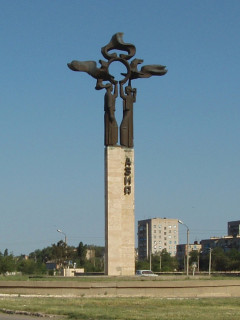
The issue of the border between Europe and Asia unexpectedly in 2004 attracted the attention of the inhabitants of the city of Yekaterinbur and became a source of doubt and dispute. Doubts arose due to the fact that Yekaterinburg was rapidly approaching Europe: 17 kilometers along the New Moscow Highway arose Memorial marking the border between Europe and Asia. Taking into account the planned growth of the city, Yekaterinburg, like Istanbul, will soon lie both in Asia and in Europe.
 Obelisk Europe-Asia on the New Moscow Trakt near Yekatrinburg
 The border question between Europe and Asia near Yekaterinburg repeatedly discussed at several conferences, of which the most representative was the All-Russian scientific and practical conference "Ekaterinburg: from a factory-fortress to the Eurasian capital" held in Yekaterinburg on May 23-24, 2002. At this conference, several reports were devoted to the problem of the border, and in the resolution of the conference, among other things, it was stated:
Consider scientifically justified historically established conduct Europe-Asia borders along the watershed of the mountain strip of the Middle Urals and the eastern foothills. Due to the complex pattern of the watershed line, the actual position of the border at specific points can be chosen within a certain strip, the axial line of which is the watershed.
The border strip near the city of Novouralsk, the city of Pervouralsk and the village. Kurganovo, Polevskoy district, passes through the points: Mount Hanging Stone, Mount Kotel, Mount Chubarova, Mount Berezovaya, Chusovodstroy, Varnachi Mountains, Mount Khrustalnaya, pos. Chusovskoye lake, northern environs of the village. Kurganovo. At the same time, it crosses the western and southwestern parts of the Municipal Formation "City of Yekaterinburg".
Doubts about the correct location of the installed commemorative The sign is also caused by the fact that at this point of the motorway there are no signs of a pass, which should be at the point of the watershed of the European and Asian Rivers. But such a pass is visible at the historical obelisk on the Old Moscow Highway. However, this is not the same pass.
Where to draw the border between Europe and Asia in the Sverdlovsk region?
A discussion between political scientist Vadim Dubichev and a member of the Russian Geographical Society, deputy Evgeny Artyukhov about where to draw the border between Europe and Asia in the Urals in the Sverdlovsk region?
Historical obelisk on the Europe-Asia border
 New obelisk on Berezovaya Gora near Yekaterinburg
 In the 15-17 centuries and even later, the Ural Range was the border between the Kazan and Siberian khanates and was perceived as the border of Siberia. After joining the Muscovite state of these parts of the Horde the ridge practically remained the border between the Siberian lands and the old Moscow districts lying to the west of the Urals. But memory retained this symbolic feature for a long time.
The current obelisk was erected in 2008 in the imperial style to replace the historical one in the same place. The place was chosen on Mount Berezovaya, since it served as Poklonnaya Hill, the simplest. People passing along the highway believed that it was here that the border between Russia and Siberia was located. Convicts who went to Siberia traditionally here they said goodbye to their homeland and took the land as a souvenir. Here is what Vasily Nemirovich-Danchenko (Russian writer, traveler, journalist, elder brother of a famous theater figure) wrote about this obelisk:
“Border of Europe and Asia. How many tears have been shed here! The unfortunate in shackles looked back from here for the last time, at their abandoned homeland forever and ever. A distant, unwelcome, alien and cold land starts from here. New life, new people, new suffering! I can imagine what thoughts swirled through the head of the poor exile when he leaned on this frontier column for a short rest. Maybe burning tears fell on every stone at its foot.
This historic obelisk was erected here in honor of the visit to the Urals by the heir Tsarevich Nikolai Alexandrovich(future Emperor Alexander II).
 Photo of a historical obelisk from the book by D.I. Mendeleev "Ural iron industry in 1899". Taken July 11, 1899.
 An inscription was carved on the border post: “In memory of the visit to this place by Their Imperial Highnesses the Sovereign Heir Tsesarevich and Grand Duke Alexander Nikolaevich in 1837, and Duke Maximilian of Leuchtenberg in 1845.” Later, on the wooden fence of the monument, they hung plates: on the left side - "Europe" and on the right - "Asia".
In the 1920s, the monument was partially destroyed, the tablet was knocked down, and no one remembered what event this stone pillar was erected in honor of. In 1946, by a special resolution of the Pervouralsk city executive committee, the monument was restored, later put up a cast iron fence. Since that time, the obelisk has become trademark of Pervouralsk. In the summer of 1982, the obelisk was lined with polished slabs and a "border" of serpentine stone was laid across the road. In the 1950s, a cast iron fence was made around the post, which was replaced with posts with chains in the mid-1990s.
 Director of the Pervouralsk Novotrubny Plant Fyodor Danilov (second from left) and US Vice President Richard Nixon on the border between Europe and Asia in July 1959 (from the plant's museum).
  In 2006, it was decided to put the obelisk on budget funds. They decided to move the old monument to a campsite altogether, under pressure from the public, the administration of Pervouralsk compromised. Historical the obelisk was moved 300 meters a little lower down the slope of Mount Berezovaya - to the spring of Fyodor Danilov on a new road.
Another old obelisk is located near Urzhumka station near Zlatoust. In 1892, as a sign of the completion of the construction of a section of the Trans-Siberian Railway, the obelisk "Europe-Asia" was erected. The boundary pillar is made of hewn granite "bricks", which were used in the lining of roadside structures. The author of the project is N. G. Garin-Mikhailovsky.
Video about the border between Europe and Asia
Where is the border between Europe and Asia?
Transfer of the First educational channel "Tales of Boyarshinov". Education for all. . © TV company SGU TV.
From cockroach to dragon: border between Europe and Asia in imperial science, Ural identity and provincial esotericism
Lecture by Yevgeny Rabinovich, Associate Professor of the Department of Cultural Studies of the Ural Federal University, on how the idea of the border between Europe and Asia, born by Tatishchev’s imagination with the aim of geographically assimilation of Russia to European empires, becomes a specific Ural way of overcoming provinciality. Thus, the outskirts of Europe and Asia becomes the center of Eurasia.
Obelisks and commemorative signs on the border of Europe and Asia
Most of the monuments and signs were installed in the Urals, but there are also in Kazakhstan and the Stavropol Territory. It is planned to install a sign in Rostov-on-Don. But in Istanbul there are only signs at the Bosphorus Bridge. In many places, such signs on the border of parts of the world are a kind of tourist magnets. People come here to take pictures of weddings, like at the sign on the pass over the Ural-Tau ridge on the M5 Ural federal highway near Zlatoust. Some of the signs are just signs or columns. Perhaps the most complete list of all the signs is listed and photographed in, where this list of obelisks and signs was taken from. Unfortunately, some of the signs have been destroyed and therefore are not included in the list.
 |
1. Strait Yugorsky SharThe sign in the form of a pillar with a sign and an anchor is located on the shore of the Yugorsky Shar Strait in the place where Vaigach Island is closest to the mainland. It is the northernmost Europe-Asia sign on the mainland Coordinates: 69°48’20.5″s. sh. 60°43’27.7″E d. |
2. The extreme eastern point of EuropeThe sign is set to the easternmost continental point of Europe. The sign is located between the upper reaches of the Malaya Usa and Malaya Shchuchya rivers in the polar Urals (the border of the Yamalo-Nenets Autonomous Okrug and the Komi Republic). Extreme geographic eastern point Europe is located on Novaya Island in the northeast of Severny Island of the Novaya Zemlya archipelago. Coordinates: 67°45’13.2″s. sh. 66°13’38.3″E d. |
|
 |
3. Sign at the station Polar UralInstalled on the platform of the Polyarny Ural station of the Vorkuta-Labytnanga branch. Coordinates: 67°00’50.2″s. sh. 65°06’48.4″E d. |
 |
4. The plate on the pass Shchekurinsky pass (Mount Neroika)A poorly visible sign stands on the Shchekurinsky pass in the Subpolar Urals near the village of Saranpaul. The sign was placed along the watershed of the Bolshoi Patok and Schekurya rivers near Mount Neroika. Coordinates: 64°39’21.1″s. sh. 59°41'09.4"E d. |
 |
5. Sign on the gas pipeline "Shining of the North"Sign "Europe-Asia" next to the gas pipeline "Shining of the North" near the village of Vuktyl, Komi Republic. Installed by gas workers, located on the road leading from the village of Vuktyl along the Siyaniye Severa gas pipeline to the central base natural park Yugydva. Coordinates: 63°17’21.8″s. sh. 59°20’43.5″E d. |
 |
6. Sign At the source of the PechoraThe cast-iron sign is installed at the source of the Pechora River. Coordinates: 62°11’56.2″s. sh. 59°26’37.1″E d. |
 |
7. Sign at an altitude of 708.9 m north of Mount YanyghachechahlA self-made sign in the form of a wooden pole with tablets, fortified in a cairn, was installed at a height of 708.9 m north of Mount Yanyghachechahl in the subpolar Urals, north of the city of Ivdel, Sverdlovsk region. On the other side of Mount Yanyghachechahl is the Dyatlov Pass. Coordinates: 62°01'47.6"s. sh. 59°26'07.9"E d. |
8. Sign on Mount Saclaimsori-ChakhlThe sign is installed on Mount Saclaimsori-Chakhl, where eight borders converge: Europe, Asia, Perm and Sverdlovsk regions, the Komi Republic, the basins of the three great rivers of Russia - the Ob (Purma), Pechora (Malaya Khozya) and the Volga (Vishera). The sign "Europe-Asia" was installed on July 25, 1997. On the pillar there is an inscription: "Governor Igumnov in memory of descendants!" Coordinates: 61°39’47.3″s. sh. 59°20’56.2″E d. |
|
 |
9. Sign on the pass Popovsky UvalThe sign was installed on the Popovsky Uval pass (height with a mark of 774 m) on the road from Ivdel to the Siberian mine. There is a European face on one side of the pillar, and an Asian face on the other. Coordinates: 60°57’39.9″s. sh. 59°23’05.4″E d. |
 |
10. Sign at the Kazan StoneOn the way from Severouralsk to the waterfalls on the Zhigolan River, at the foot of the Kazansky stone. Nearby were two granite slabs with the inscription "Europe and Asia", but they were broken. Coordinates: 60°03’56.2″s. sh. 59°03’41.3″E d. |
 |
11. Sign near the village of KytlymThe sign is located near the village of Kytlym, 8 km along the road leading to Upper Kosva, at the foot of Mount Kosvinsky stone. Coordinates: 59°29’27.9″s. sh. 58°59’23.5″E d. |
12. Sign at the village of PavdaThe sign stands at the fork of three forest roads leading to Pavda, Kytlym and Rastyos. Coordinates: 59°20’00.0″s. sh. 59°08’55.3″E d. |
|
14. Obelisk near the village of PromyslaThe obelisk is located 9 km from the village of Promysla on the Kachkanar-Chusovaya road. There is an observation deck across the road from the obelisk. The road is crossed by a line marking the borders of parts of the world. This obelisk is in the photo in the title of this article. Coordinates: 58°33’42.3″s. sh. 59°13’56.5″E d. |
|
15. Obelisk at the Ural Ridge StationThe sign was installed on the platform of the Ural Ridge station in 2003 in honor of the 125th anniversary of the Sverdlovsk railway. Coordinates: 58°24’44.1″s. sh. 59°23’47.4″E d. |
|
16. 276th km of the Gornozavodsk railwayIdentical metal trusses in the form of trihedral pyramids were installed on both sides of the railway track in 1878 during the construction of the Gornozavodskaya railway. The obelisks are located on the 276th kilometer of the road, between Evropeyskaya station and o.p. The Ural Ridge (6 km from the European, 8 km from the Ural Ridge). Coordinates: 58°24'06.0"s. sh. 59°19’37.4″E d. |
|
17. Chapel near the village of KedrovkaInstalled in 1868 by order and at the expense of the gold miners of the Northern Urals. He was described by Mamin-Sibiryak. It is located 4 km from the village of Kedrovka on the Kushva-Serebryanka highway (through V. Barancha) on a pass north of Mount Kedrovka. Coordinates: 58°11’21.2″s. sh. 59°26'04.5"E d. |
|
18. Obelisk on a logging road near the village of BaranchinskyObelisk on a logging road near the village of Baranchinsky. It is located to the west, on the pass south of Mount Kedrovka. The sign was cast from cast iron at the Baranchinsky Electromechanical Plant and decorated with an ornament. Coordinates: 58°08’39.0″s. sh. 59°26’51.7″E d. |
|
19. Stella at the Great Ural PassThe stella is located on the Great Ural Pass along the Serebryansky tract (N. Tagil - Serebryanka) near the village of Sinegorsky. Installed in 1967 in honor of the 50th anniversary of the Great October Revolution by the workers of the Sinegorsky timber industry enterprise (designed by A.A. Schmidt). Coordinates: 57°53’43.1″s. sh. 59°33’53.6″E d. |
|
20. Pillar near the village of ElizavetinskoyeA pillar made of wood was installed near the village of Elizavetinskoye on the old Demidov tract near Mount Red Pillar. Coordinates: 57°47’20.9″s. sh. 59°37’54.7″E d. |
|
21. Obelisk near the village of UraletsThe obelisk was installed near the village of Uralets on the pass through the ridge of the Veseliye Gory in 1961 in honor of Yuri Gagarin's space flight. The author of the project is V.P. Krasavchenko. The obelisk was built by the workers of the mechanical plant in the village of Uralets. Coordinates: 57°40’38.0″s. sh. 59°41’58.5″E d. |
|
 |
22. Sign at Mount BilimbayA sign with the words "Merry Mountains" (as the ridge is called) on east slope Mount Bilimbay at the side of the logging road. Coordinates: 57°32’44.9″s. sh. 59°41’35.0″E d. |
23. Tablet at the Old Man-StoneInstalled on the side of the road leading from Karpushikha to the foot of the Old Stone. A modest wooden tablet on a wooden post with the inscription "Europe-Asia" carved and either a cross or a pointer. Coordinates: 57°28’55.0″s. sh. 59°45’53.3″E d. |
|
 |
24. Obelisk with a sundial near NovouralskThe obelisk with a sundial was installed by the tourists of the Kedr club in 1985. The author of the project is Boris Shitikov. The guys from the teenage tourist club "Neiva" helped to install the pole and set it up along the solar meridian. Coordinates: 57°13’19.6″s. sh. 59°59’20.7″E d. |
25. Stone promise at the Old Bilimbaevskaya road near NovouralskOn the western slope of Mount Medvezhka, on the old Bilimbaevskaya road (the road from Novouralsk to the gardens), a marble slab was installed with the inscription "Here the Europe-Asia sign will be installed in honor of the builders of the city." Coordinates: 57°11’27.1″s. sh. 60°02’37.5″E d. |
|
26. Sign on Mount MedvezhkaAt the top of Mount Medvezhka, the Europe-Asia Sign is installed in the form of a metal triangular pyramid. It is located on the south side of small rocks at the top. Coordinates: 57°11’11.7″s. sh. 60°04’10.3″E d. |
|
27. Pillar on the Bunar Range PassThe pillar was installed in 1966 on the road going through Bilimbay to Murzinka. It is located between the villages of Pochinok and Taraskovo on a well-marked pass through the Bunar Range. The installation site does not coincide with the main watershed. Coordinates: 57°05'01.0"s. sh. 59°58’17.2″E d. |
|
28. Sign on Mount KotelThe sign in the form of two kissing doves was installed on the Day of the Border Guard in 2011 by tourists from Yekaterinburg and Novouralsk. Coordinates: 56°58’18.0″s. sh. 60°06’02.0″E d. |
|
29. Obelisk near Vershina stationThe obelisk was erected near the Vershina station during preparations for the VI World Festival of Youth and Students, held in Moscow in 1957. Coordinates: 56°52’55.0″s. sh. 60°03’56.3″E d. |
|
30. New obelisk on Mount BerezovayaIt is located on the Old Moscow Highway at the foot of Mount Berezovaya not far from the entrance to Pervouralsk from Yekaterinburg. At this place, the very first sign "Europe - Asia" was installed in honor of the visit of the Urals by Tsarevich Alexander Nikolayevich in 1837. In 2008, a granite monument was erected in its place, and the old monument was moved to the New Moscow Tract. Coordinates: 56°52’13.0″s. sh. 60°02’52.0″E d. |
|
 |
31. Historical obelisk near PervouralskMoved from the historic site on Mount Berezovaya to the Novo-Moskovsky tract near Pervouralsk. Coordinates: 56°52'04.0"s. sh. 60°02’41.7″E d. |
32. Obelisk on the Novo-Moskovsky tract near YekaterinburgThis obelisk was installed in 2004 and is located at 17 km of the Novo-Moskovsky tract near Yekaterinburg. Coordinates: 56°49’55.7″s. sh. 60°21’02.6″E d. |
|
33. Stella on the road Revda-DegtyarskThe stele on the road from Revda to Degtyarsk was installed in 1984 on the occasion of the 250th anniversary of Revda, but the place of installation is far from the main watershed. Coordinates: 56°46’14.8″s. sh. 60°01’35.7″E d. |
|
34. Owl sign at Stone MountainThe obelisk "Owl" was installed by students of school No. 21 in the city of Revda on Mount Kamennaya of the Revdinsky-Ufaley Range. The inscriptions "Europe" and "Asia" are laid out with stones on the ground. Coordinates: 56°45'05.4"s. sh. 60°00’20.2″E d. |
|
35. Obelisk near the village of KurganovoThe Europe-Asia obelisk was installed near the village of Kurganovo on the Polevskiy tract. Coordinates: 56°38’34.3″s. sh. 60°24’05.4″E d. |
|
36. Sign at the station MramorskayaThe sign is installed at the Mramorskaya station opposite the platform on a striped pole. In the upper part are nailed plates with pointers to parts of the world. “Ural” is written between the signs and a sable figurine is attached. Coordinates: 56°32’13.9″s. sh. 60°23’41.8″E d. |
|
38. Sign on the road Oblique ford-AsbestA sign on the road from the village of Kosoy Ford to the village of Asbest. Installed on June 16, 2007 by the guys from the Voyager Club. Coordinates: 56°28’40.6″s. sh. 60°24’06.1″E d. |
|
39. Sign near the village of Bolshiye EgustyA sign on the side of the road Slyudorudnik - Bolshiye Egusty, 2.5 km from the village of B. Egusty, on the left side. A concrete stele in the form of a sharp trihedral pyramid with signposts "Europe" and "Asia" is installed above the spring, from which the stream flows to Asia. Coordinates: 55°37’22.6″s. sh. 60°15’17.3″E d. |
|
40. Obelisk at Urzhumka stationIt was installed near the Urzhumka station of the Chelyabinsk-Zlatoust railway (the first station from Zlatoust towards Chelyabinsk) in 1892 to mark the completion of the construction of a section of the Trans-Siberian Railway. The boundary pillar is made of hewn granite "bricks", which were used in the lining of roadside structures. The author of the project is N. G. Garin-Mikhailovsky. Coordinates: The steles were installed on both sides of the bridge across the Ural River on the Uchaly-Beloretsk road between the village of Uralsk and the village of Novobayramgulovo. Coordinates: 54°05’42.5″s. sh. 59°04’04.8″E d. |
|
43. Old obelisks on the banks of the Urals near the village of NovobayramgulovoObelisks are installed on both sides of the old destroyed bridge across the Ural River. Built in 1968 according to a sketch by artist D. M. Adigamov and architect U. F. Zainikeev. The obelisks are flat steles topped with images of a sickle and a hammer, and in their lower part there is an image the globe. Coordinates: 54°05’33.9″s. sh. 59°04’11.9″E d. |
|
44. Geographical sign in VerkhneuralskA geographical sign marking the Europe-Asia border was installed in 2006 near the Ural River at the site where the Verkhneyaitskaya fortress was located. Coordinates: 53°52’27.7″s. sh. 59°12’16.8″E d. |
|
 |
47. Obelisk on the banks of the Urals in MagnitogorskThe obelisk was installed in 1979 on the right bank of the river. Ural at the entrance to the Central Bridge in honor of the 50th anniversary of the city, designed by architect V.N. Bogun. The obelisk is two massive cubes with a symbolic image of the Earth, divided into two parts with the letters "E" and "A". On the bridge itself there are 4 steles, symbolizing the border between Europe and Asia. In the center of the bridge is a unique Europe-Asia road sign. Coordinates: |
52. Signs Europe-Asia in the city of Atyrau (Kazakhstan)Signs in the form of gazebos on both sides of the bridge over the Ural River in the city of Atyrau in Kazakhstan. Coordinates: 47°06’18.0″s. sh. 51°54’53.2″E d. |
|
 |
53. Obelisk in the town of NeftekumskThe obelisk stands in the city of Neftekumsk in the Stavropol Territory. It was established here, since according to one of the options, the border between Europe and Asia runs along the Kuma-Manych depression between the Caspian and Black seas. The stele was installed in 1986. Architect: N.A. Postol. Coordinates: In Rostov-on-Don, they plan to erect a memorial sign "Europe-Asia" near the bridge over the Don River. The competition started in 2009, but there is no sign yet. |
 |
55. Conventional sign Europe-Asia in Rostov-on-DonSince there is still no sign "Europe-Asia" in Rostov-on-Don at the border, the owners of the shopping center "Tikhiy Don" in the right wing of the building of the River Station put a symbolic sign "Europe-Asia" on the Don embankment. It is located on the bridge on the second floor. However, the border goes along the Don fairway, so the sign is conditional. Approximate coordinates mark 47°12’47.8″N 39°42’38.5″E . |
 |
56. Tablets in front of the Bosphorus Bridge in IstanbulSigns "Welcome to Europa/Asia" in front of the entrances to bosphorus bridge in Istanbul in Turkey. Bridge coordinates: 41°02’45.2″N 29°02’02.0″E |
It has a huge size, occupies about 1/3 of the land (54 thousand km 2). From north to south, the length of Eurasia is about 8 thousand km, from west to east about 16 thousand km. Just like North America, Eurasia is widest in temperate latitudes.
The continent is most connected to North America in the northeast and to Africa in the southwest. In these areas, an active exchange of elements of the organic world has taken place and is taking place. Arabian Peninsula - part of Gondwana and natural conditions practically does not differ from the Sahara in North Africa.
Eurasia is washed by four oceans. The influence of the oceans affects the natural features of vast territories within the mainland, despite its huge size. Great importance to shape the nature of the continent have inland seas, deeply protruding into the land, and marginal seas near the northern and eastern shores continent.
Unlike all the continents of the Earth, several Precambrian and Epipaleozoic platforms, connected by folded belts of different geological ages, take part in the structure of Eurasia.
The relief of Eurasia is distinguished by great diversity and contrast. On the mainland there are vast lowlands and large mountainous countries and highlands. Only on the territory of Eurasia there are mountains that rise above 7 and 8 km. In the Himalayas is the highest point on Earth (Everest - 8848 m). The lowest place on land is also located in Eurasia - the Dead Sea coast (395 m below sea level).
Mountains on the continent stretch from west to east and from north to south, forming a kind of "grid", in the cells of which there are platform plains. As a result, there are many large and small basins in Eurasia. Such a relief structure is important in the formation of climates and the water network of the mainland.
The large extent from north to south and from west to east, the huge size of the mainland, the "lattice" structure of the relief determine the exceptional diversity of climates within its limits. There are almost all climatic zones and regions on the mainland.
The neighborhood of a huge landmass and the oceans surrounding it forms special features of the circulation of air masses over Eurasia. On the northern, eastern and southern margins of the continent, a peculiar monsoon circulation dominates. Only in the west of Eurasia, both in summer and in winter, the western transfer of air masses prevails and cyclones pass. In winter, over the basins of Central, South-West Asia, Siberia, the Central Asian maximum is formed, capturing most of the continent. It spreads from here towards all the oceans except the Atlantic. Dry winter monsoons form on the eastern and southern margins of the mainland, cold in the east, and hot in the south.
Most climatic zones the climates of the western and eastern coasts and continental regions are distinguished.
The large area of Eurasia, the diversity of climates and relief determine the diversity of the internal waters of the continent. There are many very large rivers belonging to the basins of all the oceans of the Earth. Numerous basins are often endorheic regions. Most of them lie in arid regions, but there are exceptions, for example, the basin of the upper and middle Volga. The rivers of the mainland belong to literally all types in terms of regime and power sources. In Eurasia, there are many lakes of various origins. There are especially many of them in the area of ancient glaciation. Baikal is distinguished by its unique properties with the largest fresh water volume of all water bodies in the world. In Eurasia, there is also one of the most saline lakes on the planet - the Dead Sea.
The climatic features of Eurasia determine the diversity external forces, forming the relief of the mainland. Here the work of surface and ground waters, wind is manifested. Large areas are occupied by landforms created by ancient ice cover.
In Eurasia, there are vast areas of permafrost. They occupy about 1/5 of the area of the mainland. These areas are characterized by a special cryogenic relief and vegetation adapted to environmental conditions.
On the mainland there are almost all vegetation zones with their inherent soils - from arctic deserts and tundra to humid equatorial forests. The zoning structure differs in the oceanic sectors and in the central part of the mainland. In the Atlantic Western Europe and Pacific East Asia, in addition to the northernmost regions occupied by tundra, forests dominate. Their composition is different in the west and east, both due to modern climatic conditions and as a result of different history of formation. In the central part of the continent, due to the high degree of continentality of the climate, treeless zones are widely represented: steppes, and. Desert formations also occupy large areas in the southwest of the mainland.
The natural resources of Eurasia are abundant and varied.
Eurasia is rich in minerals. On the ledges of the platform foundation there are deposits of various ores, gold, and diamonds. Huge reserves of coal and gas were formed in the sedimentary cover. The world's largest oil deposits are known in the Persian Gulf. Large reserves of tin, zinc, and tungsten ores have been found in mountainous countries in the east of the continent. The mountains of Paleozoic folding are rich in various minerals: the Ural Mountains - on the territory of our country, the Ore Mountains - in Europe and many others.
The water resources of the mainland are distributed very unevenly. Many areas of Europe, South and East Asia are well supplied with water, but there are territories in Central and Southwest Asia that are experiencing a sharp water shortage. The mainland has good agro-climatic and land resources. There are large areas of cultivated land within it. Eurasian forests, especially large tracts of coniferous forests, have large reserves of timber with high technical qualities.
The continent has long been inhabited. Some of its areas have exceptionally high population densities. The nature of these territories has been greatly modified by man, sometimes it is difficult to understand what was in the natural state here. Such are many regions of Western and Southern Europe, Eastern and Southern Asia. However, there are areas where the population is very rare or absent (the Far North, the arid regions of Asia, the Tibetan Plateau and other highlands). The mainland is inhabited by representatives of all races, many peoples belong to transitional anthropological types.
In foreign Eurasia, a number of large natural regions are distinguished: Northern, Western and Central Europe, the Mediterranean, South-Western, Central, Eastern, South and South-East Asia.


